Showing posts with label seahorse. Show all posts

Friday, February 13, 2015

Bonaire Dive Trip


Bonaire (/bɒˈnɛər/; Dutch: Bonaire, Papiamentu: Boneiru) is a Caribbean island which, together with Aruba and Curaçao, forms the group known as the ABC islands, located off the north coast of South America near the western part of Venezuela.

Bonaire's capital is Kralendijk. The island has a permanent population of 17,408 and an area of 294 km² (together with nearby uninhabited Klein Bonaire).

The name Bonaire is thought to have originally come from the Caquetio word 'Bonay'. The early Spanish and Dutch modified its spelling to Bojnaj and also Bonaire, which means "Good Air".

Bonaire was part of the Netherlands Antilles until the country's dissolution on 10 October 2010,[6] when the island became a special municipality within the country of the Netherlands.[7] It is now considered the Caribbean Netherlands, or BES Islands comprising three special municipalities located in the Caribbean: the islands of Bonaire, Sint Eustatius, and Saba.[7][8]


Bonaire
Boneiru  (Papiamento)
Public body of the Netherlands
Skyline of Bonaire
Flag of Bonaire
Flag
Coat of arms of Bonaire
Coat of arms
Anthem: "Tera di Solo y suave biento"
Location of  Bonaire  (circled in red)in the Caribbean  (light yellow)
Location of  Bonaire  (circled in red)
in the Caribbean  (light yellow)
Coordinates: 12°9′N 68°16′W
Country Netherlands
Incorporated into the Netherlands 10 October 2010 (dissolution of the Netherlands Antilles)
Capital
(and largest city)
Kralendijk
Government (see Politics of the Netherlands)
 • Lt. Governor Edison Rijna [1]
Area
 • Total 294 km2 (114 sq mi)
Population (2013[2])
 • Total 17,408
 • Density 59/km2 (150/sq mi)
Languages
 • Official Dutch
 • Recognised regional Papiamentu[3]
Time zone AST (UTC−4)
Calling code +599-7
ISO 3166 code BQ-BO, NL-BQ1
Currency US dollar (USD)
Internet TLD

 
Traditional old houses with cactus fences, preserved in the outdoor museum in Rincon


History

Original inhabitants


Bonaire's earliest known inhabitants were the Caquetio Indians, a branch of the Arawak who came by canoe from Venezuela in about 1000 AD. Archeological remains of Caquetio culture have been found at certain sites northeast of Kralendijk and near Lac Bay. Caquetio rock paintings and petroglyphs have been preserved in caves at Spelonk, Onima, Ceru Pungi, and Ceru Crita-Cabai. The Caquetios were apparently a very tall people, for the Spanish name for the ABC Islands was 'las Islas de los Gigantes' or 'the islands of the giants.'[9]

European arrival

In 1499, Alonso de Ojeda arrived in Curaçao and a neighbouring island that was almost certainly Bonaire. Ojeda was accompanied by Amerigo Vespucci and Juan de la Cosa. De La Cosa's Mappa Mundi of 1500 shows Bonaire and calls it Isla do Palo Brasil or "Island of Brazilwood." The Spanish conquerors decided that the three ABC Islands were useless, and in 1515 the natives were forcibly deported to work as slaves in the copper mines of Santo Domingo on the island of Hispaniola.[9]

Spanish period

In 1526, Juan de Ampies was appointed Spanish commander of the ABC Islands. He brought back some of the original Caquetio Indian inhabitants to Bonaire and Curaçao. Ampies also imported domesticated animals from Spain, including cows, donkeys, goats, horses, pigs, and sheep. The Spaniards thought that Bonaire could be used as a cattle plantation worked by natives. The cattle were raised for hides rather than meat. The Spanish inhabitants lived mostly in the inland town of Rincon which was safe from pirate attack.[9]

Dutch period

 The Dutch West India Company was founded in 1621. Starting in 1623, ships of the West India Company called at Bonaire to obtain meat, water, and wood. The Dutch also abandoned some Spanish and Portuguese prisoners there, and these people founded the town of Antriol which is a contraction of "al interior" or "inside."

The Dutch and the Spanish fought from 1568 to 1648 in what is now known as the Eighty Years War. In 1633, the Dutch, having lost the island of St. Maarten to the Spanish, retaliated by attacking Curaçao, Bonaire, and Aruba. Bonaire was conquered in March 1636. The Dutch built Fort Oranje in 1639.[10]


Fort Oranje in Kralendijk, built in 1639.

 While Curaçao emerged as a center of the slave trade, Bonaire became a plantation of the Dutch West India Company. A small number of African slaves were put to work alongside Indians and convicts, cultivating dyewood and maize and harvesting solar salt around Blue Pan. Slave quarters, built entirely of stone and too short for a man to stand upright in, still stand in the area around Rincon and along the saltpans as a grim reminder of Bonaire's repressive past.

 
Slave huts
 

British period

During the Napoleonic Wars, the Netherlands lost control of Bonaire twice, once from 1800 to 1803[citation needed] and again from 1807 to 1816.[11] During these intervals, the British had control of the neighboring island of Curaçao and of Bonaire. The ABC islands were returned to the Netherlands under the Anglo-Dutch Treaty of 1814. During the period of British rule, a large number of white traders settled on Bonaire, and they built the settlement of Playa (Kralendijk) in 1810.

Emancipation

From 1816 until 1868, Bonaire remained a government plantation. In 1825, there were about 300 government-owned slaves on the island. Gradually many of the slaves were freed, and became freemen with an obligation to render some services to the government. The remaining slaves were freed on 30 September 1862 under the Emancipation Regulation. A total of 607 government slaves and 151 private slaves were freed at that time.[9]

 
Salt piles

Allotment


In 1867 the government sold most of the public lands, and in 1870 they sold the saltpans. The entire population became dependent on two large private landowners, and this caused a great deal of suffering for many people. Many inhabitants were forced to move to Aruba, Curaçao, or Venezuela.[9]

World War II

During the German occupation of the Netherlands during World War II, Bonaire was a protectorate of Britain and the United States. The American army built the Flamingo Airport as an air force base. After Germany invaded the Netherlands on 10 May 1940, many Dutch and German citizens were interned in a camp on Bonaire for the duration of war.[12][13] In 1944, Princess Juliana of the Netherlands and Eleanor Roosevelt visited the troops on Bonaire.[9]

Post-war

After the war, the economy of Bonaire continued to develop. The airport was converted to civilian use and the former internment camp was converted to become the first hotel on Bonaire.[14] The Dutch Schunck family built a clothing factory known as Schunck's Kledingindustrie Bonaire.

 In 1964, Trans World Radio began broadcasting from Bonaire. Radio Netherlands Worldwide built two short wave transmitters on Bonaire in 1969.

 The second major hotel (Bonaire Beach Hotel)[15] was completed in 1962. Salt production resumed in 1966 when the salt pans were expanded and modernized by the Antilles International Salt Company, a subsidiary of the International Salt Company.[16]

The Bonaire Petroleum Corporation (BOPEC) oil terminal was opened in 1975 for trans-shipping oil.[17]


Economy

 
Diver on the "Hilma Hooker


Bonaire's economy is mainly based on tourism. The island caters mainly to scuba divers and snorkelers, as there are few sandy beaches, while the surrounding reefs are easily accessible from the shore.

 Bonaire is world renowned for its excellent scuba diving and is consistently rated among the best diving locations in the world. Bonaire's license plates carry the logo Divers Paradise (in English).

 Bonaire is also consistently recognized as one of the best destinations for snorkeling. Wind surfers also make a strong group of island tourists, as the east side of the island (facing the Caribbean Sea) has the large waves and wind gusts needed for windsurfing.

Lac Bay, in the south east, is shallow, yet windy, and hence is considered an excellent place for intermediate sailors to improve their skills. Tourism infrastructure in Bonaire is contemporary and based on time-share resorts. There are a few small bed and breakfasts. Most resorts have an on-site dive shop. The rest are affiliated with a dive operation.


Ecology

The island is fringed by coral reefs which are accessible from the shore along the lee side of the island facing west southwest. The entire Bonaire coastline was designated a marine sanctuary in an effort to preserve and protect the delicate coral reefs and marine life dependent on those reefs. Montastraea annularis was the most common coral during a recent 2011 survey.[29]


The coral reef around uninhabited Klein Bonaire is particularly well preserved, and it draws divers, snorkelers, and boaters. Bonaire also has several coral reefs where seahorses can be found.

 
American flamingos
Flamingos are drawn to the brackish water, which harbors the shrimp upon which they feed.


Bonaire is also famed for its flamingo populations and its donkey sanctuary.


Donkey colony 
Starting in the 16th century, the Dutch raised sheep, goats, pigs, horses and donkeys on Bonaire, and the descendants of the goats and donkeys roam the island today, with a small population of pigs roaming as well. Bonaire is also home to the ecologically vulnerable Yellow-shouldered Amazon.


The island of Bonaire has always been at the forefront of nature preservation and conservation and was ecologically responsible long before the mainstream efforts found today.

With the Bonaire Marine Park and the protective status of the Washington Slagbaai National Park, it was only logical to further explore optimal ways to deal with waste and recycled products.


Green Initiatives

Due to a public-private sector partnership, programs are being developed to advance the local awareness and attitudes toward conservation and habitat preservation in order to proactively protect Bonaire's ecosystem.

A new sewage treatment plant will contribute to protecting the reefs and the seawater quality. In March 2013 Selibon NV, the national garbage-processing plant, opened an environmental court where the general public can bring glass, cans, paper, scrap metal, cardboard, batteries, motor oil, cooking oil, electronics, mobile phones and textiles.

 BonRecycling BV is committed to recycling waste products in Bonaire and to create awareness among the people of Bonaire about the importance and benefits of recycling. Dive Friends Bonaire started a Debris Free Bonaire program that emphasises collecting debris washed ashore and delivering it to the dive shop for separation in preparation for handling by BonRecyling.

Source: Wikipedia.org 


Somebody Come and Play in Traffic with Me! Earn as You Learn, Grow as You Go!

The Man Inside the Man
from
Sinbad the Sailor Man
A
JMK's Production


Share this page, If you liked It Pass it on, If you loved It Follow Me!


TTFN
CYA Later Taters!
Thanks for watching.
Donnie/ Sinbad the Sailor Man

Somebody Come and Play in "Traffic" with me. If you would like to "Join" A Growing Biz Op! Here is Your Chance to get in an Earn While You Learn to Do "The Thing" with us all here at Traffic Authority.

Simply click this link and Grow as you Go Come and Play In Traffic With Me and My Team at Traffic Authority!

P.S. Everybody Needs Traffic! Get Top Tier North American Traffic Here!


TFN

CYA Later Taters

Thanks for stopping by.

Donnie/ Sinbad the Sailor Man

Sunday, January 20, 2013

The Great Barrier Reef~ "Treasures Of The Great Barrier Reef"


Published on Mar 16, 2012

Recording sights that will astonish even experienced divers, NOVA documents an extraordinary day in the life of the largest coral reef in the world, capturing for the first time the annual spawning of coral and other unusual creatures of the reef.  Original broadcast date: 11/28/95 Topic: animal biology/behavior, environment/ecology, geography/oceanography.


The Great Barrier Reef is the world's largest coral reef system[1][2] composed of over 2,900 individual reefs[3] and 900 islands stretching for over 2,600 kilometers (1,600 mi) over an area of approximately 344,400 square kilometers (133,000 sq mi).[4][5]

The reef is located in the Coral Sea, off the coast of Queensland, Australia.

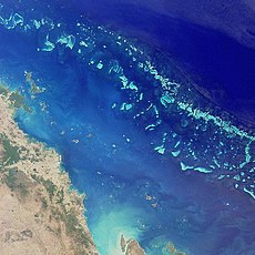
The Great Barrier Reef can be seen from outer space and is the world's biggest single structure made by living organisms.[6] This reef structure is composed of and built by billions of tiny organisms, known as coral polyps.[7]

It supports a wide diversity of life and was selected as a World Heritage Site in 1981.[1][2] CNN labeled it one of the seven natural wonders of the world.[8] The Queensland National Trust named it a state icon of Queensland.[9]

A large part of the reef is protected by the Great Barrier Reef Marine Park, which helps to limit the impact of human use, such as fishing and tourism. Other environmental pressures on the reef and its ecosystem include runoff, climate change accompanied by mass coral bleaching, and cyclic population outbreaks of the crown-of-thorns starfish.

According to a study published in October 2012 by the Proceedings of the National Academy of Sciences, the reef has lost more than half its coral cover since 1985.[10]

The Great Barrier Reef has long been known to and used by the Aboriginal Australian and Torres Strait Islander peoples, and is an important part of local groups' cultures and spirituality. The reef is a very popular destination for tourists, especially in the Whitsunday Islands and Cairns regions. Tourism is an important economic activity for the region, generating $1 billion per year.[11]


Geology and geography


Satellite image of part of the Great Barrier Reef adjacent to the Queensland coastal areas of Airlie Beach and Mackay.
The Great Barrier Reef is a distinct feature of the East Australian Cordillera division. It includes the smaller Murray Islands.[12] It reaches from Torres Strait (between Bramble Cay, its northernmost island, and the south coast of Papua New Guinea) in the north to the unnamed passage between Lady Elliot Island (its southernmost island) and Fraser Island in the south. Lady Elliot Island is located 1,915 km (1,190 mi) southeast of Bramble Cay as the crow flies.[13]

Australia has moved northwards at a rate of 7 cm (2.8 in) per year, starting during the Cainozoic.[14] Eastern Australia experienced a period of tectonic uplift, which moved the drainage divide in Queensland 400 km (250 mi) inland. Also during this time, Queensland experienced volcanic eruptions leading to central and shield volcanoes and basalt flows.[15]

Some of these granitic outcrops have become high islands.[16] After the Coral Sea Basin formed, coral reefs began to grow in the Basin, but until about 25 million years ago, northern Queensland was still in temperate waters south of the tropics—too cool to support coral growth.[17]

The Great Barrier Reef's development history is complex; after Queensland drifted into tropical waters, it was largely influenced by reef growth and decline as sea level changed.[18]

Reefs can increase in diameter by 1 to 3 centimeters (0.39 to 1.2 in) per year, and grow vertically anywhere from 1 to 25 cm (0.39 to 9.8 in) per year; however, they grow only above a depth of 150 meters (490 ft) due to their need for sunlight, and cannot grow above sea level.[19]

When Queensland edged into tropical waters 24 million years ago, some coral grew,[20] but a sedimentation regime quickly developed with erosion of the Great Dividing Range; creating river deltas, oozes and turbidites, unsuitable conditions for coral growth. 10 million years ago, the sea level significantly lowered, which further enabled sedimentation.

The reef's substrate may have needed to build up from the sediment until its edge was too far away for suspended sediments to inhibit coral growth. In addition, approximately 400,000 years ago there was a particularly warm interglacial period with higher sea levels and a 4 °C (7 °F) water temperature change.[21]


The land that formed the substrate of the current Great Barrier Reef was a coastal plain formed from the eroded sediments of the Great Dividing Range with some larger hills (some of which were themselves remnants of older reefs[22] or volcanoes[16]).[14]

The Reef Research Center, a Cooperative Research Center, has found coral 'skeleton' deposits that date back half a million years.[23] The Great Barrier Reef Marine Park Authority (GBRMPA) considers the earliest evidence of complete reef structures to have been 600,000 years ago.[24]

According to the GBRMPA, the current, living reef structure is believed to have begun growing on the older platform about 20,000 years ago.[24] The Australian Institute of Marine Science agrees, placing the beginning of the growth of the current reef at the time of the Last Glacial Maximum. At around that time, sea level was 120 meters (390 ft) lower than it is today.[22]

From 20,000 years ago until 6,000 years ago, sea level rose steadily. As it rose, the corals could then grow higher on the hills of the coastal plain. By around 13,000 years ago the sea level was only 60 meters (200 ft) lower than the present day, and corals began to grow around the hills of the coastal plain, which were, by then, continental islands.

As the sea level rose further still, most of the continental islands were submerged. The corals could then overgrow the hills, to form the present cays and reefs. Sea level here has not risen significantly in the last 6,000 years.[22]

The CRC Reef Research Center estimates the age of the present, living reef structure at 6,000 to 8,000 years old.[23]

The remains of an ancient barrier reef similar to the Great Barrier Reef can be found in The Kimberley, Western Australia.[25]

The Great Barrier Reef World Heritage Area has been divided into 70 bio-regions,[26] of which 30 are reef bio-regions.[27][28]

In the northern part of the Great Barrier Reef, ribbon reefs and deltaic reefs have formed; these structures are not found in the rest of the reef system.[23] There are no atolls in the system,[29] and reefs attached to the mainland are rare.[14]

Fringing reefs are distributed widely, but are most common towards the southern part of the Great Barrier Reef, attached to high islands, for example, the Whitsunday Islands. Lagoonal reefs are found in the southern Great Barrier Reef, and further north, off the coast of Princess Charlotte Bay. Cresentic reefs are the most common shape of reef in the middle of the system, for example the reefs surrounding Lizard Island.

Cresentic reefs are also found in the far north of the Great Barrier Reef Marine Park, and in the Swain Reefs (2022 degrees south). Planar reefs are found in the northern and southern parts, near Cape York Peninsula, Princess Charlotte Bay, and Cairns. Most of the islands on the reef are found on planar reefs.[30]


The Great Barrier Reef is clearly visible from aircraft flying over it.


Heron Island, a coral cay in the southern Great Barrier Reef


The Great Barrier Reef supports a diversity of life, including many vulnerable or endangered species, some of which may be endemic to the reef system.[31][32]


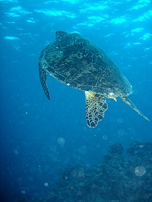
Green sea turtle on the Great Barrier Reef
Thirty species of whales, dolphins, and porpoises have been recorded in the Great Barrier Reef, including the dwarf minke whale, Indo-Pacific humpback dolphin, and the humpback whale. Large populations of dugongs live there.[32][33][34]

 More than 1,500 fish species live on the reef, including the clown-fish, red bass, red-throat emperor, and several species of snapper and coral trout.[33]

Forty-nine species mass spawn, while eighty-four other species spawn elsewhere in their range.[35] Seventeen species of sea snake live on the Great Barrier Reef in warm waters up to 50 meters (160 ft) deep and are more common in the southern than in the northern section. None found in the Great Barrier Reef World Heritage Area are endemic, nor are any endangered.[36]


A variety of colorful corals on Flynn Reef near Cairns

Six species of sea turtles come to the reef to breed – the green sea turtle, leatherback sea turtle, hawksbill turtle, loggerhead sea turtle, flatback turtle, and the olive ridley. The green sea turtles on the Great Barrier Reef have two genetically distinct populations, one in the northern part of the reef and the other in the southern part.[37]

Fifteen species of sea grass in beds attract the dugongs and turtles,[33] and provide fish habitat.[38] The most common genera of sea grasses are Halophila and Halodule.[39]

Saltwater crocodiles live in mangrove and salt marshes on the coast near the reef.[40] Nesting has not been reported, and the salt water crocodile population in the GBRWHA is wide-ranging but low density.[36]

Around 125 species of shark, stingray, skates or chimaera live on the reef.[41][42] Close to 5,000 species of mollusc have been recorded on the reef, including the giant clam and various nudibranchs and cone snails.[33] Forty-nine species of pipefish and nine species of seahorse have been recorded.[36] 

At least seven species of frog inhabit the islands.[43]
215 species of birds (including 22 species of seabirds and 32 species of shorebirds) visit the reef or nest or roost on the islands,[44] including the white-bellied sea eagle and roseate tern.[33]

Most nesting sites are on islands in the northern and southern regions of the Great Barrier Reef, with 1.4 to 1.7 million birds using the sites to breed.[45][46]

The islands of the Great Barrier Reef also support 2,195 known plant species; three of these are endemic. The northern islands have 300–350 plant species which tend to be woody, whereas the southern islands have 200 which tend to be herbaceous; the Whitsunday region is the most diverse, supporting 1,141 species. The plants are propagated by birds.[43]


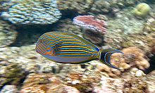
A Striped Surgeonfish amongst the coral on Flynn Reef
There are at least 330 species of ascidians on the reef system with the diameter of 1–10 cm (0.4–4 in). Between 300–500 species of bryozoans live on the reef.[42] Four hundred coral species, both hard corals and soft corals inhabit the reef.[33]

The majority of these spawn gametes, breeding in mass spawning events that are triggered by the rising sea temperatures of spring and summer, the lunar cycle, and the diurnal cycle. Reefs in the inner Great Barrier Reef spawn during the week after the full moon in October, while the outer reefs spawn in November and December.[47]

Its common soft corals belong to 36 genera.[48] Five hundred species of marine algae or seaweed live on the reef,[33] including thirteen species of genus Halimeda, which deposit calcareous mounds up to 100 meters (110 yd) wide, creating mini-ecosystems on their surface which have been compared to rainforest cover.[49]

Source: Wikipedia.org

Somebody Come and Play in Traffic with Me! Earn as You Learn, Grow as You Go!

The Man Inside the Man
from
Sinbad the Sailor Man
A
JMK's Production


Share this page, If you liked It Pass it on, If you loved It Follow Me!


TTFN
CYA Later Taters!
Thanks for watching.
Donnie/ Sinbad the Sailor Man

Somebody Come and Play in "Traffic" with me. If you would like to "Join" A Growing Biz Op! Here is Your Chance to get in an Earn While You Learn to Do "The Thing" with us all here at Traffic Authority.

Simply click this link and Grow as you Go Come and Play In Traffic With Me and My Team at Traffic Authority!

P.S. Everybody Needs Traffic! Get Top Tier North American Traffic Here!

Wednesday, November 7, 2012

Reef Life~ (Koh Tao) Gulf of Thailand


Uploaded on Jul 9, 2009
 
A selection of HD Underwater Video clips filmed during Liquid Media Videography courses from around various dive sites, Chumpon Pinnacles, Southwest Pinnacles, Sail Rock, White Rock, Twin Peaks, Japanese Gardens, Ao Leuk, King Kong Rock and many more.

If you are planning a dive trip to Koh Tao, this is just some of what you might see, this HD Underwater Video footage has been filmed on Underwater Videography Training Courses and internships with Liquid Media.

Filmed by Alan Tansey

Music Emptiness by Alexander Blu on Jamendo.com


http://www.liquidmedia.co.th/

or check out our facebook fan page for the latest in video news from Koh tao.
http://www.facebook.com/pages/Ban-Ko-Tao-Thailand/Liquid-Media-Koh-Tao/582895...


Somebody Come and Play in Traffic with Me! Earn as You Learn, Grow as You Go!

The Man Inside the Man
from
Sinbad the Sailor Man
A
JMK's Production


Share this page, If you liked It Pass it on, If you loved It Follow Me!


TTFN
CYA Later Taters!
Thanks for watching.
Donnie/ Sinbad the Sailor Man

Somebody Come and Play in "Traffic" with me. If you would like to "Join" A Growing Biz Op! Here is Your Chance to get in an Earn While You Learn to Do "The Thing" with us all here at Traffic Authority.

Simply click this link and Grow as you Go Come and Play In Traffic With Me and My Team at Traffic Authority!

P.S. Everybody Needs Traffic! Get Top Tier North American Traffic Here!

Monday, October 22, 2012

"Great Barrier Reef Australia" ~by Neil Parris


Learning to scuba dive on the Great Barrier Reef, Australia, back in the year 2000.

We had a 1 week training course including 9 dives on a live-a-board which moved between different reefs.

Video includes parts of the P.A.D.I open water certification including navigation, removing mask.

Lots of fish, turtles, corals and other amazing underwater life.

Fran is wearing pink fins, and Neil has odd blue and green fins.

The last two minutes show some library footage from Cairns Dive Center.


The Great Barrier Reef is the world's largest coral reef system[1][2] composed of over 2,900 individual reefs[3] and 900 islands stretching for over 2,600 kilometers (1,600 mi) over an area of approximately 344,400 square kilometers (133,000 sq mi).[4][5]

The reef is located in the Coral Sea, off the coast of Queensland, Australia.

The Great Barrier Reef can be seen from outer space and is the world's biggest single structure made by living organisms.[6]

This reef structure is composed of and built by billions of tiny organisms, known as coral polyps.[7]

It supports a wide diversity of life and was selected as a World Heritage Site in 1981.[1][2] CNN labeled it one of the seven natural wonders of the world.[8]

The Queensland National Trust named it a state icon of Queensland.[9]

A large part of the reef is protected by the Great Barrier Reef Marine Park, which helps to limit the impact of human use, such as fishing and tourism.

Other environmental pressures on the reef and its ecosystem include runoff, climate change accompanied by mass coral bleaching, and cyclic population outbreaks of the crown-of-thorns starfish.

According to a study published in October 2012 by the Proceedings of the National Academy of Sciences, the reef has lost more than half its coral cover since 1985.[10]

The Great Barrier Reef has long been known to and used by the Aboriginal Australian and Torres Strait Islander peoples, and is an important part of local groups' cultures and spirituality.

The reef is a very popular destination for tourists, especially in the Whitsunday Islands and Cairns regions. Tourism is an important economic activity for the region, generating $1 billion per year.[11]


Geology and geography


Satellite image of part of the Great Barrier Reef adjacent to the Queensland coastal areas of Airlie Beach and Mackay.
 
 
The Great Barrier Reef is a distinct feature of the East Australian Cordillera division. It includes the smaller Murray Islands.[12]

It reaches from Torres Strait (between Bramble Cay, its northernmost island, and the south coast of Papua New Guinea) in the north to the unnamed passage between Lady Elliot Island (its southernmost island) and Fraser Island in the south.

Lady Elliot Island is located 1,915 km (1,190 mi) southeast of Bramble Cay as the crow flies.[13]

Australia has moved northwards at a rate of 7 cm (2.8 in) per year, starting during the Cainozoic.[14]

Eastern Australia experienced a period of tectonic uplift, which moved the drainage divide in Queensland 400 km (250 mi) inland.

Also during this time, Queensland experienced volcanic eruptions leading to central and shield volcanoes and basalt flows.[15]

Some of these granitic outcrops have become high islands.[16]

After the Coral Sea Basin formed, coral reefs began to grow in the Basin, but until about 25 million years ago, northern Queensland was still in temperate waters south of the tropics—too cool to support coral growth.[17]

The Great Barrier Reef's development history is complex; after Queensland drifted into tropical waters, it was largely influenced by reef growth and decline as sea level changed.[18]

Reefs can increase in diameter by 1 to 3 centimeters (0.39 to 1.2 in) per year, and grow vertically anywhere from 1 to 25 cm (0.39 to 9.8 in) per year; however, they grow only above a depth of 150 meters (490 ft) due to their need for sunlight, and cannot grow above sea level.[19]

When Queensland edged into tropical waters 24 million years ago, some coral grew,[20] but a sedimentation regime quickly developed with erosion of the Great Dividing Range; creating river deltas, oozes and turbidites, unsuitable conditions for coral growth.

10 million years ago, the sea level significantly lowered, which further enabled sedimentation.

The reef's substrate may have needed to build up from the sediment until its edge was too far away for suspended sediments to inhibit coral growth.

In addition, approximately 400,000 years ago there was a particularly warm interglacial period with higher sea levels and a 4 °C (7 °F) water temperature change.[21]


The land that formed the substrate of the current Great Barrier Reef was a coastal plain formed from the eroded sediments of the Great Dividing Range with some larger hills (some of which were themselves remnants of older reefs[22] or volcanoes[16]).[14]

The Reef Research Center, a Cooperative Research Center, has found coral 'skeleton' deposits that date back half a million years.[23]

The Great Barrier Reef Marine Park Authority (GBRMPA) considers the earliest evidence of complete reef structures to have been 600,000 years ago.[24]

According to the GBRMPA, the current, living reef structure is believed to have begun growing on the older platform about 20,000 years ago.[24]

The Australian Institute of Marine Science agrees, placing the beginning of the growth of the current reef at the time of the Last Glacial Maximum.

At around that time, sea level was 120 meters (390 ft) lower than it is today.[22]

From 20,000 years ago until 6,000 years ago, sea level rose steadily.

As it rose, the corals could then grow higher on the hills of the coastal plain.

By around 13,000 years ago the sea level was only 60 meters (200 ft) lower than the present day, and corals began to grow around the hills of the coastal plain, which were, by then, continental islands.

As the sea level rose further still, most of the continental islands were submerged.

The corals could then overgrow the hills, to form the present cays and reefs. Sea level here has not risen significantly in the last 6,000 years.[22]

The CRC Reef Research Center estimates the age of the present, living reef structure at 6,000 to 8,000 years old.[23]

The remains of an ancient barrier reef similar to the Great Barrier Reef can be found in The Kimberley, Western Australia.[25]

The Great Barrier Reef World Heritage Area has been divided into 70 bio-regions,[26] of which 30 are reef bio-regions.[27][28]

In the northern part of the Great Barrier Reef, ribbon reefs and deltaic reefs have formed; these structures are not found in the rest of the reef system.[23]

There are no atolls in the system,[29] and reefs attached to the mainland are rare.[14]

Fringing reefs are distributed widely, but are most common towards the southern part of the Great Barrier Reef, attached to high islands, for example, the Whitsunday Islands.

Lagoonal reefs are found in the southern Great Barrier Reef, and further north, off the coast of Princess Charlotte Bay.

Cresentic reefs are the most common shape of reef in the middle of the system, for example the reefs surrounding Lizard Island.

Cresentic reefs are also found in the far north of the Great Barrier Reef Marine Park, and in the Swain Reefs (2022 degrees south).

Planar reefs are found in the northern and southern parts, near Cape York Peninsula, Princess Charlotte Bay, and Cairns. Most of the islands on the reef are found on planar reefs.[30]


The Great Barrier Reef is clearly visible from aircraft flying over it.


Heron Island, a coral cay in the southern Great Barrier Reef


The Great Barrier Reef supports a diversity of life, including many vulnerable or endangered species, some of which may be endemic to the reef system.[31][32]


Green sea turtle on the Great Barrier Reef
 
 
Thirty species of whales, dolphins, and porpoises have been recorded in the Great Barrier Reef, including the dwarf minke whale, Indo-Pacific humpback dolphin, and the humpback whale. Large populations of dugongs live there.[32][33][34]

 More than 1,500 fish species live on the reef, including the clown-fish, red bass, red-throat emperor, and several species of snapper and coral trout.[33]

Forty-nine species mass spawn, while eighty-four other species spawn elsewhere in their range.[35] 
 
Seventeen species of sea snake live on the Great Barrier Reef in warm waters up to 50 meters (160 ft) deep and are more common in the southern than in the northern section. 
 
None found in the Great Barrier Reef World Heritage Area are endemic, nor are any endangered.[36]


A variety of colorful corals on Flynn Reef near Cairns

Six species of sea turtles come to the reef to breed – the green sea turtle, leatherback sea turtle, hawksbill turtle, loggerhead sea turtle, flatback turtle, and the olive ridley
 
The green sea turtles on the Great Barrier Reef have two genetically distinct populations, one in the northern part of the reef and the other in the southern part.[37]

Fifteen species of sea grass in beds attract the dugongs and turtles,[33] and provide fish habitat.[38] The most common genera of sea grasses are Halophila and Halodule.[39]

Saltwater crocodiles live in mangrove and salt marshes on the coast near the reef.[40] 
 
Nesting has not been reported, and the salt water crocodile population in the GBRWHA is wide-ranging but low density.[36]

Around 125 species of shark, stingray, skates or chimaera live on the reef.[41][42] 
 
Close to 5,000 species of mollusc have been recorded on the reef, including the giant clam and various nudibranchs and cone snails.[33] 
 
 Forty-nine species of pipefish and nine species of seahorse have been recorded.[36]

At least seven species of frog inhabit the islands.[43]
 
215 species of birds (including 22 species of seabirds and 32 species of shorebirds) visit the reef or nest or roost on the islands,[44] including the white-bellied sea eagle and roseate tern.[33]

Most nesting sites are on islands in the northern and southern regions of the Great Barrier Reef, with 1.4 to 1.7 million birds using the sites to breed.[45][46]

The islands of the Great Barrier Reef also support 2,195 known plant species; three of these are endemic. 
 
The northern islands have 300–350 plant species which tend to be woody, whereas the southern islands have 200 which tend to be herbaceous; the Whitsunday region is the most diverse, supporting 1,141 species. The plants are propagated by birds.[43]


A Striped Surgeonfish amongst the coral on Flynn Reef
 
 
There are at least 330 species of ascidians on the reef system with the diameter of 1–10 cm (0.4–4 in). Between 300–500 species of bryozoans live on the reef.[42] 
 
Four hundred coral species, both hard corals and soft corals inhabit the reef.[33]

The majority of these spawn gametes, breeding in mass spawning events that are triggered by the rising sea temperatures of spring and summer, the lunar cycle, and the diurnal cycle. 
 
Reefs in the inner Great Barrier Reef spawn during the week after the full moon in October, while the outer reefs spawn in November and December.[47]

Its common soft corals belong to 36 genera.[48] 
 
Five hundred species of marine algae or seaweed live on the reef,[33] including thirteen species of genus Halimeda, which deposit calcareous mounds up to 100 meters (110 yd) wide, creating mini-ecosystems on their surface which have been compared to rainforest cover.[49]

Source: Wikipedia.org

Somebody Come and Play in Traffic with Me! Earn as You Learn, Grow as You Go!

The Man Inside the Man
from
Sinbad the Sailor Man
A
JMK's Production


Share this page, If you liked It Pass it on, If you loved It Follow Me!


TTFN
CYA Later Taters!
Thanks for watching.
Donnie/ Sinbad the Sailor Man

Somebody Come and Play in "Traffic" with me. If you would like to "Join" A Growing Biz Op! Here is Your Chance to get in an Earn While You Learn to Do "The Thing" with us all here at Traffic Authority.

Simply click this link and Grow as you Go Come and Play In Traffic With Me and My Team at Traffic Authority!

P.S. Everybody Needs Traffic! Get Top Tier North American Traffic Here!