Showing posts with label The Caribbean Sea. Show all posts

Friday, February 13, 2015

Bonaire Dive Trip


Bonaire (/bɒˈnɛər/; Dutch: Bonaire, Papiamentu: Boneiru) is a Caribbean island which, together with Aruba and Curaçao, forms the group known as the ABC islands, located off the north coast of South America near the western part of Venezuela.

Bonaire's capital is Kralendijk. The island has a permanent population of 17,408 and an area of 294 km² (together with nearby uninhabited Klein Bonaire).

The name Bonaire is thought to have originally come from the Caquetio word 'Bonay'. The early Spanish and Dutch modified its spelling to Bojnaj and also Bonaire, which means "Good Air".

Bonaire was part of the Netherlands Antilles until the country's dissolution on 10 October 2010,[6] when the island became a special municipality within the country of the Netherlands.[7] It is now considered the Caribbean Netherlands, or BES Islands comprising three special municipalities located in the Caribbean: the islands of Bonaire, Sint Eustatius, and Saba.[7][8]


Bonaire
Boneiru  (Papiamento)
Public body of the Netherlands
Skyline of Bonaire
Flag of Bonaire
Flag
Coat of arms of Bonaire
Coat of arms
Anthem: "Tera di Solo y suave biento"
Location of  Bonaire  (circled in red)in the Caribbean  (light yellow)
Location of  Bonaire  (circled in red)
in the Caribbean  (light yellow)
Coordinates: 12°9′N 68°16′W
Country Netherlands
Incorporated into the Netherlands 10 October 2010 (dissolution of the Netherlands Antilles)
Capital
(and largest city)
Kralendijk
Government (see Politics of the Netherlands)
 • Lt. Governor Edison Rijna [1]
Area
 • Total 294 km2 (114 sq mi)
Population (2013[2])
 • Total 17,408
 • Density 59/km2 (150/sq mi)
Languages
 • Official Dutch
 • Recognised regional Papiamentu[3]
Time zone AST (UTC−4)
Calling code +599-7
ISO 3166 code BQ-BO, NL-BQ1
Currency US dollar (USD)
Internet TLD

 
Traditional old houses with cactus fences, preserved in the outdoor museum in Rincon


History

Original inhabitants


Bonaire's earliest known inhabitants were the Caquetio Indians, a branch of the Arawak who came by canoe from Venezuela in about 1000 AD. Archeological remains of Caquetio culture have been found at certain sites northeast of Kralendijk and near Lac Bay. Caquetio rock paintings and petroglyphs have been preserved in caves at Spelonk, Onima, Ceru Pungi, and Ceru Crita-Cabai. The Caquetios were apparently a very tall people, for the Spanish name for the ABC Islands was 'las Islas de los Gigantes' or 'the islands of the giants.'[9]

European arrival

In 1499, Alonso de Ojeda arrived in Curaçao and a neighbouring island that was almost certainly Bonaire. Ojeda was accompanied by Amerigo Vespucci and Juan de la Cosa. De La Cosa's Mappa Mundi of 1500 shows Bonaire and calls it Isla do Palo Brasil or "Island of Brazilwood." The Spanish conquerors decided that the three ABC Islands were useless, and in 1515 the natives were forcibly deported to work as slaves in the copper mines of Santo Domingo on the island of Hispaniola.[9]

Spanish period

In 1526, Juan de Ampies was appointed Spanish commander of the ABC Islands. He brought back some of the original Caquetio Indian inhabitants to Bonaire and Curaçao. Ampies also imported domesticated animals from Spain, including cows, donkeys, goats, horses, pigs, and sheep. The Spaniards thought that Bonaire could be used as a cattle plantation worked by natives. The cattle were raised for hides rather than meat. The Spanish inhabitants lived mostly in the inland town of Rincon which was safe from pirate attack.[9]

Dutch period

 The Dutch West India Company was founded in 1621. Starting in 1623, ships of the West India Company called at Bonaire to obtain meat, water, and wood. The Dutch also abandoned some Spanish and Portuguese prisoners there, and these people founded the town of Antriol which is a contraction of "al interior" or "inside."

The Dutch and the Spanish fought from 1568 to 1648 in what is now known as the Eighty Years War. In 1633, the Dutch, having lost the island of St. Maarten to the Spanish, retaliated by attacking Curaçao, Bonaire, and Aruba. Bonaire was conquered in March 1636. The Dutch built Fort Oranje in 1639.[10]


Fort Oranje in Kralendijk, built in 1639.

 While Curaçao emerged as a center of the slave trade, Bonaire became a plantation of the Dutch West India Company. A small number of African slaves were put to work alongside Indians and convicts, cultivating dyewood and maize and harvesting solar salt around Blue Pan. Slave quarters, built entirely of stone and too short for a man to stand upright in, still stand in the area around Rincon and along the saltpans as a grim reminder of Bonaire's repressive past.

 
Slave huts
 

British period

During the Napoleonic Wars, the Netherlands lost control of Bonaire twice, once from 1800 to 1803[citation needed] and again from 1807 to 1816.[11] During these intervals, the British had control of the neighboring island of Curaçao and of Bonaire. The ABC islands were returned to the Netherlands under the Anglo-Dutch Treaty of 1814. During the period of British rule, a large number of white traders settled on Bonaire, and they built the settlement of Playa (Kralendijk) in 1810.

Emancipation

From 1816 until 1868, Bonaire remained a government plantation. In 1825, there were about 300 government-owned slaves on the island. Gradually many of the slaves were freed, and became freemen with an obligation to render some services to the government. The remaining slaves were freed on 30 September 1862 under the Emancipation Regulation. A total of 607 government slaves and 151 private slaves were freed at that time.[9]

 
Salt piles

Allotment


In 1867 the government sold most of the public lands, and in 1870 they sold the saltpans. The entire population became dependent on two large private landowners, and this caused a great deal of suffering for many people. Many inhabitants were forced to move to Aruba, Curaçao, or Venezuela.[9]

World War II

During the German occupation of the Netherlands during World War II, Bonaire was a protectorate of Britain and the United States. The American army built the Flamingo Airport as an air force base. After Germany invaded the Netherlands on 10 May 1940, many Dutch and German citizens were interned in a camp on Bonaire for the duration of war.[12][13] In 1944, Princess Juliana of the Netherlands and Eleanor Roosevelt visited the troops on Bonaire.[9]

Post-war

After the war, the economy of Bonaire continued to develop. The airport was converted to civilian use and the former internment camp was converted to become the first hotel on Bonaire.[14] The Dutch Schunck family built a clothing factory known as Schunck's Kledingindustrie Bonaire.

 In 1964, Trans World Radio began broadcasting from Bonaire. Radio Netherlands Worldwide built two short wave transmitters on Bonaire in 1969.

 The second major hotel (Bonaire Beach Hotel)[15] was completed in 1962. Salt production resumed in 1966 when the salt pans were expanded and modernized by the Antilles International Salt Company, a subsidiary of the International Salt Company.[16]

The Bonaire Petroleum Corporation (BOPEC) oil terminal was opened in 1975 for trans-shipping oil.[17]


Economy

 
Diver on the "Hilma Hooker


Bonaire's economy is mainly based on tourism. The island caters mainly to scuba divers and snorkelers, as there are few sandy beaches, while the surrounding reefs are easily accessible from the shore.

 Bonaire is world renowned for its excellent scuba diving and is consistently rated among the best diving locations in the world. Bonaire's license plates carry the logo Divers Paradise (in English).

 Bonaire is also consistently recognized as one of the best destinations for snorkeling. Wind surfers also make a strong group of island tourists, as the east side of the island (facing the Caribbean Sea) has the large waves and wind gusts needed for windsurfing.

Lac Bay, in the south east, is shallow, yet windy, and hence is considered an excellent place for intermediate sailors to improve their skills. Tourism infrastructure in Bonaire is contemporary and based on time-share resorts. There are a few small bed and breakfasts. Most resorts have an on-site dive shop. The rest are affiliated with a dive operation.


Ecology

The island is fringed by coral reefs which are accessible from the shore along the lee side of the island facing west southwest. The entire Bonaire coastline was designated a marine sanctuary in an effort to preserve and protect the delicate coral reefs and marine life dependent on those reefs. Montastraea annularis was the most common coral during a recent 2011 survey.[29]


The coral reef around uninhabited Klein Bonaire is particularly well preserved, and it draws divers, snorkelers, and boaters. Bonaire also has several coral reefs where seahorses can be found.

 
American flamingos
Flamingos are drawn to the brackish water, which harbors the shrimp upon which they feed.


Bonaire is also famed for its flamingo populations and its donkey sanctuary.


Donkey colony 
Starting in the 16th century, the Dutch raised sheep, goats, pigs, horses and donkeys on Bonaire, and the descendants of the goats and donkeys roam the island today, with a small population of pigs roaming as well. Bonaire is also home to the ecologically vulnerable Yellow-shouldered Amazon.


The island of Bonaire has always been at the forefront of nature preservation and conservation and was ecologically responsible long before the mainstream efforts found today.

With the Bonaire Marine Park and the protective status of the Washington Slagbaai National Park, it was only logical to further explore optimal ways to deal with waste and recycled products.


Green Initiatives

Due to a public-private sector partnership, programs are being developed to advance the local awareness and attitudes toward conservation and habitat preservation in order to proactively protect Bonaire's ecosystem.

A new sewage treatment plant will contribute to protecting the reefs and the seawater quality. In March 2013 Selibon NV, the national garbage-processing plant, opened an environmental court where the general public can bring glass, cans, paper, scrap metal, cardboard, batteries, motor oil, cooking oil, electronics, mobile phones and textiles.

 BonRecycling BV is committed to recycling waste products in Bonaire and to create awareness among the people of Bonaire about the importance and benefits of recycling. Dive Friends Bonaire started a Debris Free Bonaire program that emphasises collecting debris washed ashore and delivering it to the dive shop for separation in preparation for handling by BonRecyling.

Source: Wikipedia.org 


Somebody Come and Play in Traffic with Me! Earn as You Learn, Grow as You Go!

The Man Inside the Man
from
Sinbad the Sailor Man
A
JMK's Production


Share this page, If you liked It Pass it on, If you loved It Follow Me!


TTFN
CYA Later Taters!
Thanks for watching.
Donnie/ Sinbad the Sailor Man

Somebody Come and Play in "Traffic" with me. If you would like to "Join" A Growing Biz Op! Here is Your Chance to get in an Earn While You Learn to Do "The Thing" with us all here at Traffic Authority.

Simply click this link and Grow as you Go Come and Play In Traffic With Me and My Team at Traffic Authority!

P.S. Everybody Needs Traffic! Get Top Tier North American Traffic Here!


TFN

CYA Later Taters

Thanks for stopping by.

Donnie/ Sinbad the Sailor Man

Sunday, January 20, 2013

Marine Life Caribbean Sea

Uploaded on Dec 15, 2008
 Netssa1 

http://www.Netssa.com - The best website for booking your hotel in Cuba.
Scuba Diving and Snorkeling in the Caribbean, is unforgettable event.
Scuba Diving Centers Cuba: http://www.netssa.com/scuba_diving_cuba.html
Snorkeling Guide Cuba: http://www.netssa.com/snorkeling_cuba.html


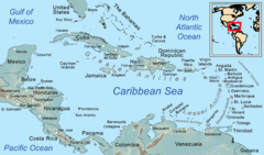
The Caribbean Sea is a sea of the Atlantic Ocean located in the tropics of the Western hemisphere. It is bounded by Mexico and Central America to the west and southwest, to the north by the Greater Antilles, to the east by the Lesser Antilles, and to the south by South America.[1]

The entire area of the Caribbean Sea, the numerous islands of the West Indies, and adjacent coasts, are collectively known as the Caribbean. The Caribbean Sea is one of the largest seas and has an area of about 2,754,000 km² (1,063,000 sq. mi.).[2]

The sea's deepest point is the Cayman Trough, between the Cayman Islands and Jamaica, at 7,686 m (25,220 ft) below sea level. The Caribbean coastline has many gulfs and bays: the Gulf of Gonâve, Gulf of Venezuela, Gulf of Darién, Golfo de los Mosquitos, Gulf of Paria and Gulf of Honduras.

 Caribbean Sea
A map of the Caribbean Sea

History

The name "Caribbean" is derived from the Caribs, one of the dominant American Indian groups in the region at the time of European contact during the late 15th century. After the discovery of the West Indies by Christopher Columbus in 1492, the Spanish term Antillas was assigned to the lands; stemming from this, "Sea of the Antilles" is a common alternative name for the Caribbean Sea in various European languages. During the first century of development, the Spanish dominance was undisputed.


Tulum, Maya city on the coast of the Caribbean in the state of Quintana Roo (Mexico).
The Caribbean Sea was an unknown body of water to the populations of Eurasia until 1492, when Christopher Columbus first sailed into Caribbean waters on a quest to find a sea route to Asia.

At that time the Western Hemisphere in general was unknown to Europeans. Following the discovery of the islands by Columbus, the area was quickly colonized by several Western cultures (initially Spain, then later Portugal, England, the Dutch Republic, France and Denmark).

Following the colonization of the Caribbean islands, the Caribbean Sea became a busy area for European-based marine trading and transport, and this commerce eventually attracted piracy.

Today the area is home to 22 island territories and borders 12 continental countries. Due to the abundance of sunshine, year-round tropical temperatures moderated by the almost constant trade winds, and the great variety of scenic destinations to visit, during the second half of the 20th century on into the 21st, the Caribbean Sea became a popular place for tourism.

Extent

The International Hydrographic Organization defines the limits of the Caribbean Sea as follows:[3]
In the Yucatan Channel. The same limit as that described for the Gulf of Mexico [A line joining Cape Catoche Light (21°37′N 87°04′W) with the Light on Cape San Antonio in Cuba].
On the North. In the Windward Channel - a line joining Caleta Point (74°15'W) and Pearl Point (19°40'N) in Haïti. In the Mona Passage - a line joining Cape Engano and the extreme of Agujereada (18°31′N 67°08′W) in Puerto Rico.
Eastern limits. From Point San Diego (Puerto Rico) Northward along the meridian thereof (65°39'W) to the 100 fathom line, thence Eastward and Southward, in such a manner that all islands, shoals and narrow waters of the Lesser Antilles are included in the Caribbean Sea as far as Galera Point (Northeast extremity of the island of Trinidad). From Galera Point through Trinidad to Galeota Point (Southeast extreme) and thence to Baja Point (9°32′N 61°0′W) in Venezuela.

Geology

The Caribbean Sea is an oceanic sea largely situated on the Caribbean Plate. Estimates of the sea's age range from 20,000[clarification needed] years to 570 million years. The Caribbean sea floor is divided into five basins separated from each other by underwater ridges and mountain ranges.

Atlantic Ocean enters the Caribbean through the Anegada Passage lying between the Lesser Antilles and Virgin Islands and the Windward Passage located between Cuba and Haiti. The Yucatan Channel between Mexico and Cuba links the Gulf of Mexico with the Caribbean.

The deepest points of the sea lie in Cayman Trough with depths reaching approximately 7,686 m (25,220 ft). Despite this, the Caribbean Sea is considered a relatively shallow sea in comparison to other bodies of water.


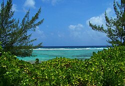
Caribbean Sea view from Bodden Town, Grand Cayman
The Caribbean sea floor is also home to two oceanic trenches: the Hispaniola Trench and Puerto Rico Trench, which put the area at a higher risk of earthquakes. Underwater earthquakes pose a threat of generating tsunamis which could have a devastating effect on the Caribbean islands. Scientific data reveals that over the last 500 years the area has seen a dozen earthquakes above 7.5 magnitude.[4] Most recently, a 7.1 earthquake struck Haiti on January 12, 2010.
 

Ecology


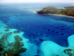
Sea of San Andrés and Providencia San Andrés and Providencia, Colombia.

A view of the Caribbean Sea from the Dominican Republic coast
The Caribbean is home to about 9% of the world's coral reefs covering about 20,000 square miles (52,000 km2), most of which are located off the Caribbean Islands and the Central American coast.[5]

During the past ten years, unusually warm Caribbean waters have been increasingly threatening Caribbean coral reefs. Coral reefs support some of the most diverse marine habitats in the world, but they are fragile ecosystems.

When tropical waters become unusually warm for extended periods of time, microscopic plants called zooxanthellae, which are symbiotic partners living within the coral polyp tissues, die off. These plants provide food for the corals, and give them their color. The result of the death and dispersal of these tiny plants is called coral bleaching, and can lead to the devastation of large areas of reef.

The habitats supported by the reefs are critical to such tourist activities as fishing and diving, and provide an annual economic value to Caribbean nations of $3.1-$4.6 billion. Continued destruction of the reefs could severely damage the region's economy.[6]

A Protocol of the Convention for the Protection and Development of the Marine Environment of the Wider Caribbean Region came in effect in 1986 to protect the various endangered marine life of the Caribbean through forbidding human activities that would advance the continued destruction of such marine life in various areas.

Currently this protocol has been ratified by 15 countries.[7] Also several charitable organizations have been formed to preserve the Caribbean marine life, such as Caribbean Conservation Corporation which seeks to study and protect sea turtles while educating others about them.[8]


Weather


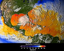
Average sea surface temperatures for the Caribbean Atlantic Ocean (25–27 August 2005.[9] Hurricane Katrina is seen just above Cuba.
The Caribbean weather is influenced by the Gulf Stream and Humboldt Current ocean currents.[10] The tropical location of the sea helps the water to maintain a warm temperature ranging from the low of 70 to mid-80 Fahrenheit (21-29 C°) by the season.

The Caribbean is a focal area for many hurricanes within the Western Hemisphere. A series of low pressure systems develop off the West coast of Africa and make their way across the Atlantic Ocean.

While most of these systems do not become tropical storms, some do. The tropical storms can develop into Atlantic hurricanes, often in the low pressure areas of the eastern Caribbean. The Caribbean hurricane season as a whole lasts from June through November, with the majority of hurricanes occurring during August and September.

On average around 9 tropical storms form each year, with 5 reaching hurricane strength. According to the National Hurricane Center 385 hurricanes occurred in the Caribbean between 1494 and 1900.
Every year hurricanes represent a potential threat to the islands of the Caribbean, due to the extremely destructive nature of these powerful weather systems.

Coral reefs can easily be damaged by violent wave action, and can be destroyed when a hurricane dumps sand or mud onto a reef. When this happens, the coral organisms are smothered and the reef dies and ultimately breaks apart.


Economy and human activity


A Caribbean beach in Isla Margarita, Venezuela.
The Caribbean region has seen a significant increase in human activity since the colonisation period. The sea is one of the largest oil production areas in the world, producing approximately 170 million tons per year.[11]

The area also generates a large fishing industry for the surrounding countries, accounting for half a million metric tons of fish a year.[12]

Human activity in the area also accounts for a significant amount of pollution, The Pan American Health Organization estimated in 1993 that only about 10% of the sewage from the Central American and Caribbean Island countries is properly treated before being released into the Sea.[11]

The Caribbean region supports a large tourist industry. The Caribbean Tourism Organization calculates that about 12 million people a year visit the area, including (in 1991–1992) about 8 million Cruise Ship tourists.

Tourism based upon scuba diving and snorkeling on coral reefs of many Caribbean islands makes a major contribution to their economies.[13]

Source: Wikipedia


TTFN
CYA Later Taters
Thanks for watching.

Donnie/ Sinbad the Sailor