Showing posts with label reptile and marine mammal species. Show all posts

Friday, February 13, 2015

Bonaire Dive Trip


Bonaire (/bɒˈnɛər/; Dutch: Bonaire, Papiamentu: Boneiru) is a Caribbean island which, together with Aruba and Curaçao, forms the group known as the ABC islands, located off the north coast of South America near the western part of Venezuela.

Bonaire's capital is Kralendijk. The island has a permanent population of 17,408 and an area of 294 km² (together with nearby uninhabited Klein Bonaire).

The name Bonaire is thought to have originally come from the Caquetio word 'Bonay'. The early Spanish and Dutch modified its spelling to Bojnaj and also Bonaire, which means "Good Air".

Bonaire was part of the Netherlands Antilles until the country's dissolution on 10 October 2010,[6] when the island became a special municipality within the country of the Netherlands.[7] It is now considered the Caribbean Netherlands, or BES Islands comprising three special municipalities located in the Caribbean: the islands of Bonaire, Sint Eustatius, and Saba.[7][8]


Bonaire
Boneiru  (Papiamento)
Public body of the Netherlands
Skyline of Bonaire
Flag of Bonaire
Flag
Coat of arms of Bonaire
Coat of arms
Anthem: "Tera di Solo y suave biento"
Location of  Bonaire  (circled in red)in the Caribbean  (light yellow)
Location of  Bonaire  (circled in red)
in the Caribbean  (light yellow)
Coordinates: 12°9′N 68°16′W
Country Netherlands
Incorporated into the Netherlands 10 October 2010 (dissolution of the Netherlands Antilles)
Capital
(and largest city)
Kralendijk
Government (see Politics of the Netherlands)
 • Lt. Governor Edison Rijna [1]
Area
 • Total 294 km2 (114 sq mi)
Population (2013[2])
 • Total 17,408
 • Density 59/km2 (150/sq mi)
Languages
 • Official Dutch
 • Recognised regional Papiamentu[3]
Time zone AST (UTC−4)
Calling code +599-7
ISO 3166 code BQ-BO, NL-BQ1
Currency US dollar (USD)
Internet TLD

 
Traditional old houses with cactus fences, preserved in the outdoor museum in Rincon


History

Original inhabitants


Bonaire's earliest known inhabitants were the Caquetio Indians, a branch of the Arawak who came by canoe from Venezuela in about 1000 AD. Archeological remains of Caquetio culture have been found at certain sites northeast of Kralendijk and near Lac Bay. Caquetio rock paintings and petroglyphs have been preserved in caves at Spelonk, Onima, Ceru Pungi, and Ceru Crita-Cabai. The Caquetios were apparently a very tall people, for the Spanish name for the ABC Islands was 'las Islas de los Gigantes' or 'the islands of the giants.'[9]

European arrival

In 1499, Alonso de Ojeda arrived in Curaçao and a neighbouring island that was almost certainly Bonaire. Ojeda was accompanied by Amerigo Vespucci and Juan de la Cosa. De La Cosa's Mappa Mundi of 1500 shows Bonaire and calls it Isla do Palo Brasil or "Island of Brazilwood." The Spanish conquerors decided that the three ABC Islands were useless, and in 1515 the natives were forcibly deported to work as slaves in the copper mines of Santo Domingo on the island of Hispaniola.[9]

Spanish period

In 1526, Juan de Ampies was appointed Spanish commander of the ABC Islands. He brought back some of the original Caquetio Indian inhabitants to Bonaire and Curaçao. Ampies also imported domesticated animals from Spain, including cows, donkeys, goats, horses, pigs, and sheep. The Spaniards thought that Bonaire could be used as a cattle plantation worked by natives. The cattle were raised for hides rather than meat. The Spanish inhabitants lived mostly in the inland town of Rincon which was safe from pirate attack.[9]

Dutch period

 The Dutch West India Company was founded in 1621. Starting in 1623, ships of the West India Company called at Bonaire to obtain meat, water, and wood. The Dutch also abandoned some Spanish and Portuguese prisoners there, and these people founded the town of Antriol which is a contraction of "al interior" or "inside."

The Dutch and the Spanish fought from 1568 to 1648 in what is now known as the Eighty Years War. In 1633, the Dutch, having lost the island of St. Maarten to the Spanish, retaliated by attacking Curaçao, Bonaire, and Aruba. Bonaire was conquered in March 1636. The Dutch built Fort Oranje in 1639.[10]


Fort Oranje in Kralendijk, built in 1639.

 While Curaçao emerged as a center of the slave trade, Bonaire became a plantation of the Dutch West India Company. A small number of African slaves were put to work alongside Indians and convicts, cultivating dyewood and maize and harvesting solar salt around Blue Pan. Slave quarters, built entirely of stone and too short for a man to stand upright in, still stand in the area around Rincon and along the saltpans as a grim reminder of Bonaire's repressive past.

 
Slave huts
 

British period

During the Napoleonic Wars, the Netherlands lost control of Bonaire twice, once from 1800 to 1803[citation needed] and again from 1807 to 1816.[11] During these intervals, the British had control of the neighboring island of Curaçao and of Bonaire. The ABC islands were returned to the Netherlands under the Anglo-Dutch Treaty of 1814. During the period of British rule, a large number of white traders settled on Bonaire, and they built the settlement of Playa (Kralendijk) in 1810.

Emancipation

From 1816 until 1868, Bonaire remained a government plantation. In 1825, there were about 300 government-owned slaves on the island. Gradually many of the slaves were freed, and became freemen with an obligation to render some services to the government. The remaining slaves were freed on 30 September 1862 under the Emancipation Regulation. A total of 607 government slaves and 151 private slaves were freed at that time.[9]

 
Salt piles

Allotment


In 1867 the government sold most of the public lands, and in 1870 they sold the saltpans. The entire population became dependent on two large private landowners, and this caused a great deal of suffering for many people. Many inhabitants were forced to move to Aruba, Curaçao, or Venezuela.[9]

World War II

During the German occupation of the Netherlands during World War II, Bonaire was a protectorate of Britain and the United States. The American army built the Flamingo Airport as an air force base. After Germany invaded the Netherlands on 10 May 1940, many Dutch and German citizens were interned in a camp on Bonaire for the duration of war.[12][13] In 1944, Princess Juliana of the Netherlands and Eleanor Roosevelt visited the troops on Bonaire.[9]

Post-war

After the war, the economy of Bonaire continued to develop. The airport was converted to civilian use and the former internment camp was converted to become the first hotel on Bonaire.[14] The Dutch Schunck family built a clothing factory known as Schunck's Kledingindustrie Bonaire.

 In 1964, Trans World Radio began broadcasting from Bonaire. Radio Netherlands Worldwide built two short wave transmitters on Bonaire in 1969.

 The second major hotel (Bonaire Beach Hotel)[15] was completed in 1962. Salt production resumed in 1966 when the salt pans were expanded and modernized by the Antilles International Salt Company, a subsidiary of the International Salt Company.[16]

The Bonaire Petroleum Corporation (BOPEC) oil terminal was opened in 1975 for trans-shipping oil.[17]


Economy

 
Diver on the "Hilma Hooker


Bonaire's economy is mainly based on tourism. The island caters mainly to scuba divers and snorkelers, as there are few sandy beaches, while the surrounding reefs are easily accessible from the shore.

 Bonaire is world renowned for its excellent scuba diving and is consistently rated among the best diving locations in the world. Bonaire's license plates carry the logo Divers Paradise (in English).

 Bonaire is also consistently recognized as one of the best destinations for snorkeling. Wind surfers also make a strong group of island tourists, as the east side of the island (facing the Caribbean Sea) has the large waves and wind gusts needed for windsurfing.

Lac Bay, in the south east, is shallow, yet windy, and hence is considered an excellent place for intermediate sailors to improve their skills. Tourism infrastructure in Bonaire is contemporary and based on time-share resorts. There are a few small bed and breakfasts. Most resorts have an on-site dive shop. The rest are affiliated with a dive operation.


Ecology

The island is fringed by coral reefs which are accessible from the shore along the lee side of the island facing west southwest. The entire Bonaire coastline was designated a marine sanctuary in an effort to preserve and protect the delicate coral reefs and marine life dependent on those reefs. Montastraea annularis was the most common coral during a recent 2011 survey.[29]


The coral reef around uninhabited Klein Bonaire is particularly well preserved, and it draws divers, snorkelers, and boaters. Bonaire also has several coral reefs where seahorses can be found.

 
American flamingos
Flamingos are drawn to the brackish water, which harbors the shrimp upon which they feed.


Bonaire is also famed for its flamingo populations and its donkey sanctuary.


Donkey colony 
Starting in the 16th century, the Dutch raised sheep, goats, pigs, horses and donkeys on Bonaire, and the descendants of the goats and donkeys roam the island today, with a small population of pigs roaming as well. Bonaire is also home to the ecologically vulnerable Yellow-shouldered Amazon.


The island of Bonaire has always been at the forefront of nature preservation and conservation and was ecologically responsible long before the mainstream efforts found today.

With the Bonaire Marine Park and the protective status of the Washington Slagbaai National Park, it was only logical to further explore optimal ways to deal with waste and recycled products.


Green Initiatives

Due to a public-private sector partnership, programs are being developed to advance the local awareness and attitudes toward conservation and habitat preservation in order to proactively protect Bonaire's ecosystem.

A new sewage treatment plant will contribute to protecting the reefs and the seawater quality. In March 2013 Selibon NV, the national garbage-processing plant, opened an environmental court where the general public can bring glass, cans, paper, scrap metal, cardboard, batteries, motor oil, cooking oil, electronics, mobile phones and textiles.

 BonRecycling BV is committed to recycling waste products in Bonaire and to create awareness among the people of Bonaire about the importance and benefits of recycling. Dive Friends Bonaire started a Debris Free Bonaire program that emphasises collecting debris washed ashore and delivering it to the dive shop for separation in preparation for handling by BonRecyling.

Source: Wikipedia.org 


Somebody Come and Play in Traffic with Me! Earn as You Learn, Grow as You Go!

The Man Inside the Man
from
Sinbad the Sailor Man
A
JMK's Production


Share this page, If you liked It Pass it on, If you loved It Follow Me!


TTFN
CYA Later Taters!
Thanks for watching.
Donnie/ Sinbad the Sailor Man

Somebody Come and Play in "Traffic" with me. If you would like to "Join" A Growing Biz Op! Here is Your Chance to get in an Earn While You Learn to Do "The Thing" with us all here at Traffic Authority.

Simply click this link and Grow as you Go Come and Play In Traffic With Me and My Team at Traffic Authority!

P.S. Everybody Needs Traffic! Get Top Tier North American Traffic Here!


TFN

CYA Later Taters

Thanks for stopping by.

Donnie/ Sinbad the Sailor Man

Saturday, December 8, 2012

SCUBA Diving Bunaken~ "Indonesia"

Uploaded on Oct 8, 2009

Scuba diving at Bunaken Island near Manado in Indonesia.

This is the best of the footage from my 2006 trip, including a baby whale shark at Lekuan.

This whale shark was only 4 or 5 feet long and had two big remoras attached to it.

More Bunaken Island and Manado  SCUBA Diving videos at http://www.bubblevision.com/underwater-videos/Bunaken-Manado/

The Bunaken National Park is a marine park in the north of Sulawesi island, Indonesia.

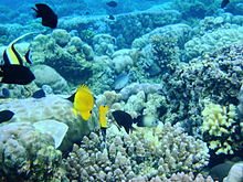
The park is located near the center of the Coral Triangle, providing habitat to 390 species of coral[2] as well as many fish, mollusc, reptile and marine mammal species.

The Park is representative of Indonesian tropical water ecosystems, consisting of sea-grass plain, coral reef, and coastal ecosystems.[3]

It was established as a national park in 1991 and is among the first of Indonesia's growing system of marine parks.

It covers a total area of 890.65 km², 97% of which is marine habitat.

The remaining 3% of the park is terrestrial, including the five islands of Bunaken, Manado Tua, Mantehage, Nain and Siladen.

The southern part of the Park covers part of the Tanjung Kelapa coast.[3]
 

Geology

North Sulawesi is considered to be a 'young' formation, of 5-24 million years of age.

The region has undergone explosive volcanism 1.5-5 million years ago, which resulted in the volcanic tuff that characterizes the existing topography.

Manado Tua is an inactive volcano formed in a classical cone shape and rising over 600 m above sea level, the highest elevation in the park.

Bunaken Island also has volcanic origins with a significant amount of uplifted fossil coral.

Nain Island is also a dome-shaped island, 139m in height. Mantehage Island is relatively flat and seems to be sinking into the sea.

The island has extensive mangrove forest flats, partially separated by saltwater channels.

Siladen is a low-lying coral sand island with no significant topography.

Arakan-Wawontulap and Molas-Wori on the mainland of North Sulawesi are relatively flat areas at the base of volcanic hills.

The absence of a continental shelf allows the coastal area of the park to drop directly down the continental slope.

The sea depth between the islands of the park is 200 to 1,840 meters.[4]


Bunaken National Park
IUCN category II (national park)
Bunaken01.JPG
Bunaken Island seen from Manado Tua island.
Map showing the location of Bunaken National Park
Bunaken NP
Location in Sulawesi
Location Sulawesi, Indonesia
Nearest city Manado
Coordinates 1°40′N 124°39′ECoordinates: 1°40′N 124°39′E
Area 890 km²
Established 1991
Visitors ca.35,000[1] (in 2003-06)
Governing body Ministry of Forestry

Flora and fauna


Bunaken National Marine Park, Manado


A very rich coral ecosystem covers most of Bunaken National Park, dominated by fringing reef and barrier reef corals.[3]

There are about 390 species of coral recorded in the waters of the Park.[2]

A distinct feature is a 25-50 meter vertical coral wall which is inhabited by 13 coral genus.

The seaweeds that can be found here include Caulerpa, Halimeda, and Padina species, while the dominant sea-grasses, in particular in the islands of Montehage and Nain, are Thalassia hemprichii, Enhallus acoroides, and Thalassodendron ciliatum.

The park is also abundant in different species of fish, marine mammals and reptiles, birds, molluscs and mangrove species.[3]

About 90 species of fish live in the waters of the park, among them being the Emperor Angelfish, Almaco Jack, Spotted Seahorse, Bluestripe Snapper, Pinkish Basslet and Two-lined monocle bream.

The species of mollusc include the Giant Clam, Horned Helmet Shells, Chambered Nautilus, and ascidians.[3]

It is claimed that this park has seven times more genera of coral than Hawaii[5], and more than 70% of all the known fish species of the Indo-Western Pacific.[6]

On land, the islands are rich in species of palm, sago, woka, silar and coconut.

Among the animal species that live on the land and the beaches are Celebes crested macaque, Timor Deer, and Sulawesi bear cuscus.

The mangrove forest of the Park contains, among others Rhizophora and Sonneratiaspecies.

This forest is also rich in species of crab, lobster, mollusc, and sea birds such as gulls, herons, sea doves, and storks.[3]

Human habitation and tourism


Nudibranch (Nembrotha cristata), a shell-less mollusc in the waters of Bunaken National Park


The area is densely populated, with 22 villages inside the park comprising about 35,000 people.

Most locals work as fishermen or farmers cultivating coconut, sweet potato, banana or seaweed for export, while a small number are employed in tourism as dive guides, boat operators and cottage staff.[7]

Tourism is strongly developed, with accommodation ranging from backpacker cottages to 5 star resorts.[1]

Between 2003 and 2006 the number of visitors ranged from 32,000 to 39,000 of which 8-10,000 were international visitors.[1]


Conservation and threats

Bunaken National Park was formally established in 1991 and is among the first of Indonesia's marine parks.

In 2005 Indonesia submitted an application to UNESCO for including the park on the World Heritage List.[4]

Despite its national park status and significant funding, the park has suffered a slow, continuous degradation due to a number of threats including coral mining, anchor damage, blast fishing, cyanide fishing, diving, and trash.[1]

The World Wildlife Fund provides conservation support in the National Park as part of the Sulu Sulawesi Marine Eco-region Action Plan.

This includes participatory enforcement and patrol, which resulted in significant reduction of blast fishing.[8]

Source: Wikipedia.org


Somebody Come and Play in Traffic with Me! Earn as You Learn, Grow as You Go!

The Man Inside the Man
from
Sinbad the Sailor Man
A
JMK's Production


Share this page, If you liked It Pass it on, If you loved It Follow Me!


TTFN
CYA Later Taters!
Thanks for watching.
Donnie/ Sinbad the Sailor Man

Somebody Come and Play in "Traffic" with me. If you would like to "Join" A Growing Biz Op! Here is Your Chance to get in an Earn While You Learn to Do "The Thing" with us all here at Traffic Authority.

Simply click this link and Grow as you Go Come and Play In Traffic With Me and My Team at Traffic Authority!

P.S. Everybody Needs Traffic! Get Top Tier North American Traffic Here!

Scuba Diving in Bali~ (2006) [Wreck Dive Features The USAT Liberty]


Uploaded on Oct 10, 2009

Scuba diving in Bali in 2006 with AquaMarine Diving. This 54-minute film features the USAT Liberty Wreck, Coral Garden and the Drop-off from Tulamben, macro from Seraya Secrets, Blue Lagoon and Pura Jepun from Padangbai, and the manta rays of Manta Point from Nusa Penida.

This is available as a DVD from http://www.bubblevision.com/underwater-videos/Bali/

 USAT Liberty was a United States Army transport ship torpedoed by Japanese submarine I-166 in January 1942 and beached on the island of Bali

She had been built as a design 1037 ship for the United States Shipping Board during World War I and had served in the United States Navy during that conflict as animal transport USS Liberty (ID-3461)

She was also notable as the first ship constructed at Federal Shipbuilding, Kearny, New Jersey. In 1963 a volcanic eruption moved the ship off the beach, and Liberty's wreck is now a popular dive site.


AlternateTextHere
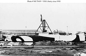
USS Liberty (ID # 3461) Fitting out at the yard of her builder, the Federal Shipbuilding Co., Kearny, New Jersey, circa September 1918. This freighter was in commission from October 1918 to May 1919.

Career (USA)
Name: USS Liberty
Builder: Federal Shipbuilding
Kearny, New Jersey
Yard number: 1
Launched: 19 June 1918
Commissioned: 7 October 1918
Decommissioned: 7 May 1919
Fate: torpedoed by I-166, 11 January 1942 , and beached
General characteristics
Displacement: 13,130 tons
Length: 411 ft 6 in (125.43 m)
Beam: 55 ft (17 m)
Draft: 26 ft 6 in (8.08 m)
Speed: 11 knots (20 km/h)
Complement: 70
Armament: 1 x 6", 1 x 3"

For more on the USAT Liberty follow this link to Wikipedia:  http://en.wikipedia.org/wiki/USAT_Liberty


Bali is a province in the country of Indonesia. The island is located in the westernmost end of the Lesser Sunda Islands, lying between Java to the west and Lombok to the east. It is one of the country's 33 provinces with the provincial capital at Denpasar towards the south of the island. The province covers a few small neighboring islands as well as the isle of Bali.

With a population recorded as 3,891,428 in the 2010 census,[3] the island is home to most of Indonesia's Hindu minority.

 In the 2000 census about 92.29% of Bali's population adhered to Balinese Hinduism while most of the remainder follow Islam. It is also the largest tourist destination in the country and is renowned for its highly developed arts, including traditional and modern dance, sculpture, painting, leather, metalworking, and music. A tourist haven for decades, Bali has seen a further surge in tourist numbers in recent years.[citation needed]


Bali was inhabited by around 2000 BC by Austronesian peoples who migrated originally from Taiwan through Maritime Southeast Asia.[4]

Culturally and linguistically, the Balinese are thus closely related to the peoples of the Indonesian archipelago, Malaysia, the Philippines, and Oceania.[5] Stone tools dating from this time have been found near the village of Cekik in the island's west.[6]

In ancient Bali, nine Hindu sects existed, namely Pasupata, Bhairawa, Siwa Shidanta, Waisnawa, Bodha, Brahma, Resi, Sora and Ganapatya. Each sect revered a specific deity as its personal Godhead.[7]

Balinese culture was strongly influenced by Indian, Chinese, and particularly Hindu culture, beginning around the 1st century AD. The name Bali dwipa ("Bali island") has been discovered from various inscriptions, including the Blanjong pillar inscription written by Sri Kesari Warmadewa in 914 AD and mentioning "Walidwipa".

It was during this time that the complex irrigation system subak was developed to grow rice. Some religious and cultural traditions still in existence today can be traced back to this period. The Hindu Majapahit Empire (1293–1520 AD) on eastern Java founded a Balinese colony in 1343. When the empire declined, there was an exodus of intellectuals, artists, priests, and musicians from Java to Bali in the 15th century.


Tanah Lot, one of the major temples in Bali

The first European contact with Bali is thought to have been made in 1585 when a Portuguese ship foundered off the Bukit Peninsula and left a few Portuguese in the service of Dewa Agung.[8]

In 1597 the Dutch explorer Cornelis de Houtman arrived at Bali and, with the establishment of the Dutch East India Company in 1602, the stage was set for colonial control two and a half centuries later when Dutch control expanded across the Indonesian archipelago throughout the second half of the nineteenth century (see Dutch East Indies). Dutch political and economic control over Bali began in the 1840s on the island's north coast, when the Dutch pitted various distrustful Balinese realms against each other.[9]

 In the late 1890s, struggles between Balinese kingdoms in the island's south were exploited by the Dutch to increase their control.

The Dutch mounted large naval and ground assaults at the Sanur region in 1906 and were met by the thousands of members of the royal family and their followers who fought against the superior Dutch force in a suicidal puputan defensive assault rather than face the humiliation of surrender.[9]

Despite Dutch demands for surrender, an estimated 1,000 Balinese marched to their death against the invaders.[10] In the Dutch intervention in Bali (1908), a similar massacre occurred in the face of a Dutch assault in Klungkung. Afterwards the Dutch governors were able to exercise administrative control over the island, but local control over religion and culture generally remained intact.

Dutch rule over Bali came later and was never as well established as in other parts of Indonesia such as Java and Maluku.

In the 1930s, anthropologists Margaret Mead and Gregory Bateson, and artists Miguel Covarrubias and Walter Spies, and musicologist Colin McPhee created a western image of Bali as "an enchanted land of aesthetes at peace with themselves and nature", and western tourism first developed on the island.[11]


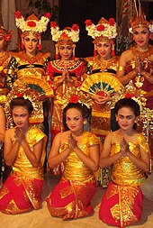
Balinese dancers show for tourists, in Ubud.

Imperial Japan occupied Bali during World War II. Bali Island was not originally a target in their Netherlands East Indies Campaign, but as the airfields on Borneo were inoperative due to heavy rains the Imperial Japanese Army decided to occupy Bali, which did not suffer from comparable weather. The island had no regular Royal Netherlands East Indies Army (KNIL) troops.

There was only a Native Auxiliary Corps Prajoda (Korps Prajoda) consisting of about 600 native soldiers and several Dutch KNIL officers under command of KNIL Lieutenant Colonel W.P. Roodenburg. On 19 February 1942 the Japanese forces landed near the town of Senoer. The island was quickly captured.[12]

During the Japanese occupation a Balinese military officer, Gusti Ngurah Rai, formed a Balinese 'freedom army'. The lack of institutional changes from the time of Dutch rule however, and the harshness of war requisitions made Japanese rule little better than the Dutch one.[13]

Following Japan's Pacific surrender in August 1945, the Dutch promptly returned to Indonesia, including Bali, immediately to reinstate their pre-war colonial administration. This was resisted by the Balinese rebels now using Japanese weapons. On 20 November 1946, the Battle of Marga was fought in Tabanan in central Bali.

Colonel I Gusti Ngurah Rai, by then 29 years old, finally rallied his forces in east Bali at Marga Rana, where they made a suicide attack on the heavily armed Dutch. The Balinese battalion was entirely wiped out, breaking the last thread of Balinese military resistance.

In 1946 the Dutch constituted Bali as one of the 13 administrative districts of the newly proclaimed State of East Indonesia, a rival state to the Republic of Indonesia which was proclaimed and headed by Sukarno and Hatta. Bali was included in the "Republic of the United States of Indonesia" when the Netherlands recognised Indonesian independence on 29 December 1949.

The 1963 eruption of Mount Agung killed thousands, created economic havoc and forced many displaced Balinese to be transmigrated to other parts of Indonesia. Mirroring the widening of social divisions across Indonesia in the 1950s and early 1960s, Bali saw conflict between supporters of the traditional caste system, and those rejecting these traditional values.

Politically, this was represented by opposing supporters of the Indonesian Communist Party (PKI) and the Indonesian Nationalist Party (PNI), with tensions and ill-feeling further increased by the PKI's land reform programs.[9]

An attempted coup in Jakarta was put down by forces led by General Suharto. The army became the dominant power as it instigated a violent anti-communist purge, in which the army blamed the PKI for the coup.

Most estimates suggest that at least 500,000 people were killed across Indonesia, with an estimated 80,000 killed in Bali, equivalent to 5% of the island's population.[14] With no Islamic forces involved as in Java and Sumatra, upper-caste PNI landlords led the extermination of PKI members.[15]

As a result of the 1965/66 upheavals, Suharto was able to manoeuvre Sukarno out of the presidency, and his "New Order" government reestablished relations with western countries. The pre-War Bali as "paradise" was revived in a modern form, and the resulting large growth in tourism has led to a dramatic increase in Balinese standards of living and significant foreign exchange earned for the country.[9]
A bombing in 2002 by militant Islamists in the tourist area of Kuta killed 202 people, mostly foreigners. This attack, and another in 2005, severely affected tourism, bringing much economic hardship to the island, although tourist numbers have now[when?] returned to levels before the bombings.


Geography

The island of Bali lies 3.2 km (2 mi) east of Java, and is approximately 8 degrees south of the equator. Bali and Java are separated by the Bali Strait. East to west, the island is approximately 153 km (95 mi) wide and spans approximately 112 km (69 mi) north to south; its land area is 5,632 km².

Bali's central mountains include several peaks over 3,000 meters in elevation. The highest is Mount Agung (3,031 m), known as the "mother mountain" which is an active volcano. Mountains range from centre to the eastern side, with Mount Agung the easternmost peak.

Bali's volcanic nature has contributed to its exceptional fertility and its tall mountain ranges provide the high rainfall that supports the highly productive agriculture sector. South of the mountains is a broad, steadily descending area where most of Bali's large rice crop is grown.

The northern side of the mountains slopes more steeply to the sea and is the main coffee producing area of the island, along with rice, vegetables and cattle. The longest river, Ayung River, flows approximately 75 km.

The island is surrounded by coral reefs. Beaches in the south tend to have white sand while those in the north and west have black sand. Bali has no major waterways, although the Ho River is navigable by small sampan boats. Black sand beaches between Pasut and Klatingdukuh are being developed for tourism, but apart from the seaside temple of Tanah Lot, they are not yet used for significant tourism.


Subak irrigation system

The largest city is the provincial capital, Denpasar, near the southern coast. Its population is around 491,500 (2002). Bali's second-largest city is the old colonial capital, Singaraja, which is located on the north coast and is home to around 100,000 people. Other important cities include the beach resort, Kuta, which is practically part of Denpasar's urban area, and Ubud, situated at the north of Denpasar, is the island's cultural center.

Three small islands lie to the immediate south east and all are administratively part of the Klungkung regency of Bali: Nusa Penida, Nusa Lembongan and Nusa Ceningan. These islands are separated from Bali by the Badung Strait.

To the east, the Lombok Strait separates Bali from Lombok and marks the biogeographical division between the fauna of the Indomalayan ecozone and the distinctly different fauna of Australasia. The transition is known as the Wallace Line, named after Alfred Russel Wallace, who first proposed a transition zone between these two major biomes.

When sea levels dropped during the Pleistocene ice age, Bali was connected to Java and Sumatra and to the mainland of Asia and shared the Asian fauna, but the deep water of the Lombok Strait continued to keep Lombok Island and the Lesser Sunda archipelago isolated.

Source: Wikipedia.org

Somebody Come and Play in Traffic with Me! Earn as You Learn, Grow as You Go!

The Man Inside the Man
from
Sinbad the Sailor Man
A
JMK's Production


Share this page, If you liked It Pass it on, If you loved It Follow Me!


TTFN
CYA Later Taters!
Thanks for watching.
Donnie/ Sinbad the Sailor Man

Somebody Come and Play in "Traffic" with me. If you would like to "Join" A Growing Biz Op! Here is Your Chance to get in an Earn While You Learn to Do "The Thing" with us all here at Traffic Authority.

Simply click this link and Grow as you Go Come and Play In Traffic With Me and My Team at Traffic Authority!

P.S. Everybody Needs Traffic! Get Top Tier North American Traffic Here!