Sunday, January 20, 2013

The Loin-fish~ "Open Season on the Loin-fish"

Uploaded on Sept. 9, 2010
 WPTVnews 
Local diver invents device to kill "Lion-fish" 


 Uploaded on Sept. 7, 2010
  rjnjupiter
Lion Tamer Mini Spear 


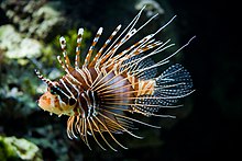
Pterois, commonly known as Lion-fish, is a genus of venomous marine fish found mostly in the Indo-Pacific. Pterois is characterized by red, white and black bands, showy pectoral fins and venomous spiky fin rays.[1][2]  

Pterois are classified into nine different species, but Pterois radiata, Pterois volitans and Pterois miles are the most commonly studied. Pterois are popular aquarium fish and are readily utilized in the culinary world.[1]

In the mid 1990s, the species P. volitans and P. miles were unintentionally introduced into the Atlantic Ocean and have become an invasive species along the East Coast of the United States,[2] the Mesoamerican Barrier Reef System, and the wider Caribbean. They are now also found in the Gulf of Mexico.[3]


Pterois
Pterois antennata
Scientific classification
Kingdom: Animalia
Phylum: Chordata
Class: Actinopterygii
Order: Scorpaeniformes
Family: Scorpaenidae
Subfamily: Pteroinae
Genus: Pterois
Oken, 1817
Species
See text.

Description

Pterois range in size from 6.2 to 42.4 cm with typical adults measuring 38 cm and weighing an average of 480 g.[2][4][5] They are well known for their ornate beauty, venomous spines and unique tentacles.[6][7]

Juvenile Lion-fish have a unique tentacle located above their eye sockets that varies in phenotype between species.[6] It is suggested that the evolution of this tentacle serves to continually attract new prey; studies also suggest that it plays a role in sexual selection.[6]

Ecology and behavior

Pterois can live from five to fifteen years and have complex courtship and mating behaviors.[8] Females release two mucus-filled egg clusters frequently, which can contain as many as fifteen thousand eggs.[8][9] Studies on Pterois reproductive habits have increased significantly in the past decade.[9]

Invasive introduction and range

Two of the nine species of Pterois, the red Lion-fish (P. volitans) and the common Lion-fish (P. miles), have established themselves as significant invasive species off the East Coast of the United States and in the Caribbean. About 93% of the invasive population is P. volitans.[24]

The red Lion-fish is found off the East Coast of the United States and the Caribbean Sea, and was likely first introduced off the Florida coast in the early to mid-1990s.[25]

It has been speculated that this introduction may have been caused when Hurricane Andrew destroyed an aquarium in southern Florida,[26] It is also believed that six Lion-fish were accidentally released in Biscayne Bay, Florida after Hurricane Andrew in 1992.[27]

However, a more recent report states National Oceanic and Atmospheric Administration (NOAA) ecologist James Morris Jr. has discovered that a Lion-fish was discovered off the coast of south Florida prior to Hurricane Andrew in 1985.[28][29]

It is also believed that the Lion-fish were purposefully discarded by unsatisfied aquarium enthusiasts.[27]

The first documented capture of Lion-fish in the Atlantic occurred in Dania Beach, Florida.[4] In 2001, NOAA documented multiple sightings of Lion-fish off the coast of Florida, Georgia, South Carolina, North Carolina, and Bermuda, and were first detected in the Bahamas in 2004.[30]

Recently (late November 2011) they have been discovered as far east as Barbados,[31] and as far south as Los Roques Archipelago and many Venezuelan continental beaches.[32]


P. volitans comprises the largest part of the invasive Lion-fish population in the Atlantic and Caribbean
Pterois volitans and Pterois miles are native to sub-tropical and tropical regions from southern Japan and southern Korea to the east coast of Australia, Indonesia, Micronesia, French Polynesia and in the South Pacific Ocean.[22]

Adult Lion-fish specimens are now found along the United States East Coast from Cape Hatteras, North Carolina, to Florida, and in Bermuda, the Bahamas, and throughout the Caribbean, including the Turks and Caicos, Haiti, Cuba, Dominican Republic, Cayman Islands, Aruba, Curacao, Bonaire, Puerto Rico, St. Croix, Belize, Honduras and Mexico.[2]

Population densities continue to increase in the invaded areas, resulting in a population boom of up to 700% in some areas between 2004 and 2008.[33] Population densities have reached levels that are orders of magnitude greater than their native ranges.[34]

Pterois are known for devouring many other aquarium fishes.[27] Pterois are unusual in that they are among the few fish species to successfully establish populations in open marine systems.[35]

Pelagic larval dispersion is assumed to occur through oceanic currents, including the Gulf Stream and the Caribbean Current. It is projected that currents could eventually result in new populations along the Gulf Coast.[36]

Ballast water can also be attributed to the dispersal.[37]

Extreme temperatures present geographical constraints in the distribution of aquatic species,[38] indicating that temperature tolerance plays a role in the Lion-fish’s survival, reproduction and range of distribution.[39]

Observational studies have shown that the abrupt differences in water temperatures north and south of Cape Hatteras directly correlate with the abundance and distribution of Pterois.[38]  

Pterois expanded along the entire eastern coast of the United States and occupied thermal-appropriate zones within ten years.[38]

Although the timeline of observations points to the east coast of Florida as the initial source of the western Atlantic invasion, the relationship of the United States East Coast and Bahamian Lion-fish invasion is uncertain.[40]

Control and eradication efforts


P. miles makes up about seven percent of the invasive lionfish population in the Atlantic and Caribbean
The population density of the invasive Lion-fish is increasing very fast, and efforts are underway in several areas to bring it under control. However, to completely eradicate the Lion-fish from its new habitats seems unlikely. A study from 2010 using population modeling used data collected about the known life history of the Lion-fish inhabiting the Caribbean coral reefs to figure out the best means of eradication.

The study showed that the most effective way to even maintain current Lion-fish population densities, at least 27% of the invasive adult populations would have to be killed monthly. The fact that Lion-fish are able to reproduce monthly throughout the entire year means that this is an effort that must be maintained monthly for the maintenance of current population densities.[41]

Even to accomplish these numbers seems unlikely, but as populations of Lion-fish continue to grow throughout the Caribbean and Western Atlantic, actions are being taken to attempt to control the quickly growing numbers.

In November 2010, the Florida Keys National Marine Sanctuary began to give out licenses to divers to kill Lion-fish inside of the sanctuary. This is the first time this has ever been done for any species in the sanctuary, in a desperate attempt to eradicate the fish. Rigorous and repeated removal of Lion-fish from invaded waters will be necessary to establish control on the exponentially expanding population.[2]

Many conservation groups across the Eastern United States are organizing hunting expeditions for Pterois. The Environment Education Foundation recently hosted its third ‘Lion-fish derby’ in Florida, offering more than $3,000 in prize money for dive teams catching the most Lion-fish.[42]

Community organizations are forming across the country in hopes of halting the ever expanding Lion-fish population.[42] Dive-masters from Cozumel to the Honduran Bay Islands routinely spear Lion-fish during dives, sometimes killing as many as eight in an hour. Based on average kills per dive, a professional diver could easily kill 3000 to 4000 Lion-fish per year (3 dives per day, 6 days per week, averaging 4+ kills per dive).[citation needed]

Other interest groups, such as NOAA, are setting up events and campaigns that encourage the killing and eating of the fish.[34]

Many people are wary of the idea of eating a venomous fish, but when properly filleted the fish is perfectly healthy to eat. Encouraging the consumption of Lion-fish could not only help to maintain a reasonable population density, but also provide an alternative fishing source to other over fished populations, such as grouper and snapper.

The Reef Environmental Education Foundation has even prepared a cookbook to help educate restaurant chefs on how they can incorporate the fish into their menu. The NOAA calls the Lion-fish a "delicious, delicately flavored fish" similar in texture to grouper.[42] Many recipes for lionfish can be found in coastal cookbooks, some including fried Lion-fish, Lion-fish ceviche, Lion-fish jerky and grilled Lion-fish.[43]

The evasiveness of the red Lion-fish is an extreme problem, and relatively little information is still known about the animal. The NOAA has research foci in place to better understand the fish and the implications surround its invasive nature.

Some of these include investigating biotechnological solutions for control of the population, and understanding how the larvae are dispersed. Another important area of study is how the population is controlled in its native area.

If we find out why it is not out of control in the Indo-Pacific, we may be able to implement a similar concept into the invasive populations, without causing unintended results such as another invasive species. NOAA also plans to further its "Lion-fish as Food" campaign, as human hunting of the fish is the only known current form of control. The NOAA also encourages people to report Lion-fish sightings to help keep a better record of dispersal.[44]


Long term effects of invasion

Lion-fish have successfully pioneered the coastal waters of the Atlantic in less than a decade and pose a major threat to reef ecological systems in these areas.

A study published in 2006 comparing their abundance from Florida to North Carolina with several species of groupers found that they were second only to the native scamp grouper and equally abundant to the graysby, gag, and rock hind.[2]

This could be due to a surplus of resource availability resulting from the over-fishing of Lion-fish predators like grouper.[45]

Although the Lion-fish has not expanded to a population size that is currently causing major ecological problems, their invasion in the United States coastal waters could lead to serious problems in the future.

One likely ecological impact caused by Pterois could be their impact on prey population numbers by directly affecting food web relationships. This could ultimately lead to reef deterioration and could negatively influence Atlantic trophic cascade.[8]

It has already been shown that Lion-fish overpopulate reef areas and display aggressive tendencies; forcing native species to move to waters where conditions might be less than desirable.[2]

Studies show that Lion-fish could be decreasing Atlantic reef diversity by up to 80%.[23] In July 2011, Lion-fish were reported for the first time in the Flower Garden Banks National Marine Sanctuary off the coast of Louisiana.[46]

Sanctuary officials said they believe the species will be a permanent fixture, but hope to monitor and possibly limit their presence.

Source: Wikipedia.org

Somebody Come and Play in Traffic with Me! Earn as You Learn, Grow as You Go!

The Man Inside the Man
from
Sinbad the Sailor Man
A
JMK's Production


Share this page, If you liked It Pass it on, If you loved It Follow Me!


TTFN
CYA Later Taters!
Thanks for watching.
Donnie/ Sinbad the Sailor Man

Somebody Come and Play in "Traffic" with me. If you would like to "Join" A Growing Biz Op! Here is Your Chance to get in an Earn While You Learn to Do "The Thing" with us all here at Traffic Authority.

Simply click this link and Grow as you Go Come and Play In Traffic With Me and My Team at Traffic Authority!

P.S. Everybody Needs Traffic! Get Top Tier North American Traffic Here!


Marine Life Caribbean Sea

Uploaded on Dec 15, 2008
 Netssa1 

http://www.Netssa.com - The best website for booking your hotel in Cuba.
Scuba Diving and Snorkeling in the Caribbean, is unforgettable event.
Scuba Diving Centers Cuba: http://www.netssa.com/scuba_diving_cuba.html
Snorkeling Guide Cuba: http://www.netssa.com/snorkeling_cuba.html


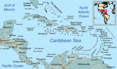
The Caribbean Sea is a sea of the Atlantic Ocean located in the tropics of the Western hemisphere. It is bounded by Mexico and Central America to the west and southwest, to the north by the Greater Antilles, to the east by the Lesser Antilles, and to the south by South America.[1]

The entire area of the Caribbean Sea, the numerous islands of the West Indies, and adjacent coasts, are collectively known as the Caribbean. The Caribbean Sea is one of the largest seas and has an area of about 2,754,000 km² (1,063,000 sq. mi.).[2]

The sea's deepest point is the Cayman Trough, between the Cayman Islands and Jamaica, at 7,686 m (25,220 ft) below sea level. The Caribbean coastline has many gulfs and bays: the Gulf of Gonâve, Gulf of Venezuela, Gulf of Darién, Golfo de los Mosquitos, Gulf of Paria and Gulf of Honduras.

 Caribbean Sea
A map of the Caribbean Sea

History

The name "Caribbean" is derived from the Caribs, one of the dominant American Indian groups in the region at the time of European contact during the late 15th century. After the discovery of the West Indies by Christopher Columbus in 1492, the Spanish term Antillas was assigned to the lands; stemming from this, "Sea of the Antilles" is a common alternative name for the Caribbean Sea in various European languages. During the first century of development, the Spanish dominance was undisputed.


Tulum, Maya city on the coast of the Caribbean in the state of Quintana Roo (Mexico).
The Caribbean Sea was an unknown body of water to the populations of Eurasia until 1492, when Christopher Columbus first sailed into Caribbean waters on a quest to find a sea route to Asia.

At that time the Western Hemisphere in general was unknown to Europeans. Following the discovery of the islands by Columbus, the area was quickly colonized by several Western cultures (initially Spain, then later Portugal, England, the Dutch Republic, France and Denmark).

Following the colonization of the Caribbean islands, the Caribbean Sea became a busy area for European-based marine trading and transport, and this commerce eventually attracted piracy.

Today the area is home to 22 island territories and borders 12 continental countries. Due to the abundance of sunshine, year-round tropical temperatures moderated by the almost constant trade winds, and the great variety of scenic destinations to visit, during the second half of the 20th century on into the 21st, the Caribbean Sea became a popular place for tourism.

Extent

The International Hydrographic Organization defines the limits of the Caribbean Sea as follows:[3]
In the Yucatan Channel. The same limit as that described for the Gulf of Mexico [A line joining Cape Catoche Light (21°37′N 87°04′W) with the Light on Cape San Antonio in Cuba].
On the North. In the Windward Channel - a line joining Caleta Point (74°15'W) and Pearl Point (19°40'N) in Haïti. In the Mona Passage - a line joining Cape Engano and the extreme of Agujereada (18°31′N 67°08′W) in Puerto Rico.
Eastern limits. From Point San Diego (Puerto Rico) Northward along the meridian thereof (65°39'W) to the 100 fathom line, thence Eastward and Southward, in such a manner that all islands, shoals and narrow waters of the Lesser Antilles are included in the Caribbean Sea as far as Galera Point (Northeast extremity of the island of Trinidad). From Galera Point through Trinidad to Galeota Point (Southeast extreme) and thence to Baja Point (9°32′N 61°0′W) in Venezuela.

Geology

The Caribbean Sea is an oceanic sea largely situated on the Caribbean Plate. Estimates of the sea's age range from 20,000[clarification needed] years to 570 million years. The Caribbean sea floor is divided into five basins separated from each other by underwater ridges and mountain ranges.

Atlantic Ocean enters the Caribbean through the Anegada Passage lying between the Lesser Antilles and Virgin Islands and the Windward Passage located between Cuba and Haiti. The Yucatan Channel between Mexico and Cuba links the Gulf of Mexico with the Caribbean.

The deepest points of the sea lie in Cayman Trough with depths reaching approximately 7,686 m (25,220 ft). Despite this, the Caribbean Sea is considered a relatively shallow sea in comparison to other bodies of water.


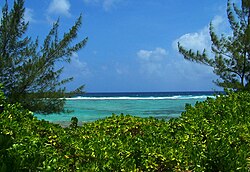
Caribbean Sea view from Bodden Town, Grand Cayman
The Caribbean sea floor is also home to two oceanic trenches: the Hispaniola Trench and Puerto Rico Trench, which put the area at a higher risk of earthquakes. Underwater earthquakes pose a threat of generating tsunamis which could have a devastating effect on the Caribbean islands. Scientific data reveals that over the last 500 years the area has seen a dozen earthquakes above 7.5 magnitude.[4] Most recently, a 7.1 earthquake struck Haiti on January 12, 2010.
 

Ecology


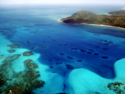
Sea of San Andrés and Providencia San Andrés and Providencia, Colombia.

A view of the Caribbean Sea from the Dominican Republic coast
The Caribbean is home to about 9% of the world's coral reefs covering about 20,000 square miles (52,000 km2), most of which are located off the Caribbean Islands and the Central American coast.[5]

During the past ten years, unusually warm Caribbean waters have been increasingly threatening Caribbean coral reefs. Coral reefs support some of the most diverse marine habitats in the world, but they are fragile ecosystems.

When tropical waters become unusually warm for extended periods of time, microscopic plants called zooxanthellae, which are symbiotic partners living within the coral polyp tissues, die off. These plants provide food for the corals, and give them their color. The result of the death and dispersal of these tiny plants is called coral bleaching, and can lead to the devastation of large areas of reef.

The habitats supported by the reefs are critical to such tourist activities as fishing and diving, and provide an annual economic value to Caribbean nations of $3.1-$4.6 billion. Continued destruction of the reefs could severely damage the region's economy.[6]

A Protocol of the Convention for the Protection and Development of the Marine Environment of the Wider Caribbean Region came in effect in 1986 to protect the various endangered marine life of the Caribbean through forbidding human activities that would advance the continued destruction of such marine life in various areas.

Currently this protocol has been ratified by 15 countries.[7] Also several charitable organizations have been formed to preserve the Caribbean marine life, such as Caribbean Conservation Corporation which seeks to study and protect sea turtles while educating others about them.[8]


Weather


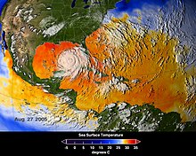
Average sea surface temperatures for the Caribbean Atlantic Ocean (25–27 August 2005.[9] Hurricane Katrina is seen just above Cuba.
The Caribbean weather is influenced by the Gulf Stream and Humboldt Current ocean currents.[10] The tropical location of the sea helps the water to maintain a warm temperature ranging from the low of 70 to mid-80 Fahrenheit (21-29 C°) by the season.

The Caribbean is a focal area for many hurricanes within the Western Hemisphere. A series of low pressure systems develop off the West coast of Africa and make their way across the Atlantic Ocean.

While most of these systems do not become tropical storms, some do. The tropical storms can develop into Atlantic hurricanes, often in the low pressure areas of the eastern Caribbean. The Caribbean hurricane season as a whole lasts from June through November, with the majority of hurricanes occurring during August and September.

On average around 9 tropical storms form each year, with 5 reaching hurricane strength. According to the National Hurricane Center 385 hurricanes occurred in the Caribbean between 1494 and 1900.
Every year hurricanes represent a potential threat to the islands of the Caribbean, due to the extremely destructive nature of these powerful weather systems.

Coral reefs can easily be damaged by violent wave action, and can be destroyed when a hurricane dumps sand or mud onto a reef. When this happens, the coral organisms are smothered and the reef dies and ultimately breaks apart.


Economy and human activity


A Caribbean beach in Isla Margarita, Venezuela.
The Caribbean region has seen a significant increase in human activity since the colonisation period. The sea is one of the largest oil production areas in the world, producing approximately 170 million tons per year.[11]

The area also generates a large fishing industry for the surrounding countries, accounting for half a million metric tons of fish a year.[12]

Human activity in the area also accounts for a significant amount of pollution, The Pan American Health Organization estimated in 1993 that only about 10% of the sewage from the Central American and Caribbean Island countries is properly treated before being released into the Sea.[11]

The Caribbean region supports a large tourist industry. The Caribbean Tourism Organization calculates that about 12 million people a year visit the area, including (in 1991–1992) about 8 million Cruise Ship tourists.

Tourism based upon scuba diving and snorkeling on coral reefs of many Caribbean islands makes a major contribution to their economies.[13]

Source: Wikipedia


TTFN
CYA Later Taters
Thanks for watching.

Donnie/ Sinbad the Sailor

The Great Barrier Reef~ "Treasures Of The Great Barrier Reef"


Published on Mar 16, 2012

Recording sights that will astonish even experienced divers, NOVA documents an extraordinary day in the life of the largest coral reef in the world, capturing for the first time the annual spawning of coral and other unusual creatures of the reef.  Original broadcast date: 11/28/95 Topic: animal biology/behavior, environment/ecology, geography/oceanography.


The Great Barrier Reef is the world's largest coral reef system[1][2] composed of over 2,900 individual reefs[3] and 900 islands stretching for over 2,600 kilometers (1,600 mi) over an area of approximately 344,400 square kilometers (133,000 sq mi).[4][5]

The reef is located in the Coral Sea, off the coast of Queensland, Australia.

The Great Barrier Reef can be seen from outer space and is the world's biggest single structure made by living organisms.[6] This reef structure is composed of and built by billions of tiny organisms, known as coral polyps.[7]

It supports a wide diversity of life and was selected as a World Heritage Site in 1981.[1][2] CNN labeled it one of the seven natural wonders of the world.[8] The Queensland National Trust named it a state icon of Queensland.[9]

A large part of the reef is protected by the Great Barrier Reef Marine Park, which helps to limit the impact of human use, such as fishing and tourism. Other environmental pressures on the reef and its ecosystem include runoff, climate change accompanied by mass coral bleaching, and cyclic population outbreaks of the crown-of-thorns starfish.

According to a study published in October 2012 by the Proceedings of the National Academy of Sciences, the reef has lost more than half its coral cover since 1985.[10]

The Great Barrier Reef has long been known to and used by the Aboriginal Australian and Torres Strait Islander peoples, and is an important part of local groups' cultures and spirituality. The reef is a very popular destination for tourists, especially in the Whitsunday Islands and Cairns regions. Tourism is an important economic activity for the region, generating $1 billion per year.[11]


Geology and geography


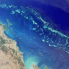
Satellite image of part of the Great Barrier Reef adjacent to the Queensland coastal areas of Airlie Beach and Mackay.
The Great Barrier Reef is a distinct feature of the East Australian Cordillera division. It includes the smaller Murray Islands.[12] It reaches from Torres Strait (between Bramble Cay, its northernmost island, and the south coast of Papua New Guinea) in the north to the unnamed passage between Lady Elliot Island (its southernmost island) and Fraser Island in the south. Lady Elliot Island is located 1,915 km (1,190 mi) southeast of Bramble Cay as the crow flies.[13]

Australia has moved northwards at a rate of 7 cm (2.8 in) per year, starting during the Cainozoic.[14] Eastern Australia experienced a period of tectonic uplift, which moved the drainage divide in Queensland 400 km (250 mi) inland. Also during this time, Queensland experienced volcanic eruptions leading to central and shield volcanoes and basalt flows.[15]

Some of these granitic outcrops have become high islands.[16] After the Coral Sea Basin formed, coral reefs began to grow in the Basin, but until about 25 million years ago, northern Queensland was still in temperate waters south of the tropics—too cool to support coral growth.[17]

The Great Barrier Reef's development history is complex; after Queensland drifted into tropical waters, it was largely influenced by reef growth and decline as sea level changed.[18]

Reefs can increase in diameter by 1 to 3 centimeters (0.39 to 1.2 in) per year, and grow vertically anywhere from 1 to 25 cm (0.39 to 9.8 in) per year; however, they grow only above a depth of 150 meters (490 ft) due to their need for sunlight, and cannot grow above sea level.[19]

When Queensland edged into tropical waters 24 million years ago, some coral grew,[20] but a sedimentation regime quickly developed with erosion of the Great Dividing Range; creating river deltas, oozes and turbidites, unsuitable conditions for coral growth. 10 million years ago, the sea level significantly lowered, which further enabled sedimentation.

The reef's substrate may have needed to build up from the sediment until its edge was too far away for suspended sediments to inhibit coral growth. In addition, approximately 400,000 years ago there was a particularly warm interglacial period with higher sea levels and a 4 °C (7 °F) water temperature change.[21]


The land that formed the substrate of the current Great Barrier Reef was a coastal plain formed from the eroded sediments of the Great Dividing Range with some larger hills (some of which were themselves remnants of older reefs[22] or volcanoes[16]).[14]

The Reef Research Center, a Cooperative Research Center, has found coral 'skeleton' deposits that date back half a million years.[23] The Great Barrier Reef Marine Park Authority (GBRMPA) considers the earliest evidence of complete reef structures to have been 600,000 years ago.[24]

According to the GBRMPA, the current, living reef structure is believed to have begun growing on the older platform about 20,000 years ago.[24] The Australian Institute of Marine Science agrees, placing the beginning of the growth of the current reef at the time of the Last Glacial Maximum. At around that time, sea level was 120 meters (390 ft) lower than it is today.[22]

From 20,000 years ago until 6,000 years ago, sea level rose steadily. As it rose, the corals could then grow higher on the hills of the coastal plain. By around 13,000 years ago the sea level was only 60 meters (200 ft) lower than the present day, and corals began to grow around the hills of the coastal plain, which were, by then, continental islands.

As the sea level rose further still, most of the continental islands were submerged. The corals could then overgrow the hills, to form the present cays and reefs. Sea level here has not risen significantly in the last 6,000 years.[22]

The CRC Reef Research Center estimates the age of the present, living reef structure at 6,000 to 8,000 years old.[23]

The remains of an ancient barrier reef similar to the Great Barrier Reef can be found in The Kimberley, Western Australia.[25]

The Great Barrier Reef World Heritage Area has been divided into 70 bio-regions,[26] of which 30 are reef bio-regions.[27][28]

In the northern part of the Great Barrier Reef, ribbon reefs and deltaic reefs have formed; these structures are not found in the rest of the reef system.[23] There are no atolls in the system,[29] and reefs attached to the mainland are rare.[14]

Fringing reefs are distributed widely, but are most common towards the southern part of the Great Barrier Reef, attached to high islands, for example, the Whitsunday Islands. Lagoonal reefs are found in the southern Great Barrier Reef, and further north, off the coast of Princess Charlotte Bay. Cresentic reefs are the most common shape of reef in the middle of the system, for example the reefs surrounding Lizard Island.

Cresentic reefs are also found in the far north of the Great Barrier Reef Marine Park, and in the Swain Reefs (2022 degrees south). Planar reefs are found in the northern and southern parts, near Cape York Peninsula, Princess Charlotte Bay, and Cairns. Most of the islands on the reef are found on planar reefs.[30]


The Great Barrier Reef is clearly visible from aircraft flying over it.


Heron Island, a coral cay in the southern Great Barrier Reef


The Great Barrier Reef supports a diversity of life, including many vulnerable or endangered species, some of which may be endemic to the reef system.[31][32]


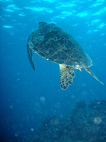
Green sea turtle on the Great Barrier Reef
Thirty species of whales, dolphins, and porpoises have been recorded in the Great Barrier Reef, including the dwarf minke whale, Indo-Pacific humpback dolphin, and the humpback whale. Large populations of dugongs live there.[32][33][34]

 More than 1,500 fish species live on the reef, including the clown-fish, red bass, red-throat emperor, and several species of snapper and coral trout.[33]

Forty-nine species mass spawn, while eighty-four other species spawn elsewhere in their range.[35] Seventeen species of sea snake live on the Great Barrier Reef in warm waters up to 50 meters (160 ft) deep and are more common in the southern than in the northern section. None found in the Great Barrier Reef World Heritage Area are endemic, nor are any endangered.[36]


A variety of colorful corals on Flynn Reef near Cairns

Six species of sea turtles come to the reef to breed – the green sea turtle, leatherback sea turtle, hawksbill turtle, loggerhead sea turtle, flatback turtle, and the olive ridley. The green sea turtles on the Great Barrier Reef have two genetically distinct populations, one in the northern part of the reef and the other in the southern part.[37]

Fifteen species of sea grass in beds attract the dugongs and turtles,[33] and provide fish habitat.[38] The most common genera of sea grasses are Halophila and Halodule.[39]

Saltwater crocodiles live in mangrove and salt marshes on the coast near the reef.[40] Nesting has not been reported, and the salt water crocodile population in the GBRWHA is wide-ranging but low density.[36]

Around 125 species of shark, stingray, skates or chimaera live on the reef.[41][42] Close to 5,000 species of mollusc have been recorded on the reef, including the giant clam and various nudibranchs and cone snails.[33] Forty-nine species of pipefish and nine species of seahorse have been recorded.[36] 

At least seven species of frog inhabit the islands.[43]
215 species of birds (including 22 species of seabirds and 32 species of shorebirds) visit the reef or nest or roost on the islands,[44] including the white-bellied sea eagle and roseate tern.[33]

Most nesting sites are on islands in the northern and southern regions of the Great Barrier Reef, with 1.4 to 1.7 million birds using the sites to breed.[45][46]

The islands of the Great Barrier Reef also support 2,195 known plant species; three of these are endemic. The northern islands have 300–350 plant species which tend to be woody, whereas the southern islands have 200 which tend to be herbaceous; the Whitsunday region is the most diverse, supporting 1,141 species. The plants are propagated by birds.[43]


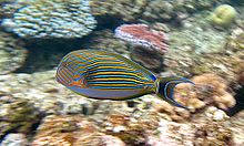
A Striped Surgeonfish amongst the coral on Flynn Reef
There are at least 330 species of ascidians on the reef system with the diameter of 1–10 cm (0.4–4 in). Between 300–500 species of bryozoans live on the reef.[42] Four hundred coral species, both hard corals and soft corals inhabit the reef.[33]

The majority of these spawn gametes, breeding in mass spawning events that are triggered by the rising sea temperatures of spring and summer, the lunar cycle, and the diurnal cycle. Reefs in the inner Great Barrier Reef spawn during the week after the full moon in October, while the outer reefs spawn in November and December.[47]

Its common soft corals belong to 36 genera.[48] Five hundred species of marine algae or seaweed live on the reef,[33] including thirteen species of genus Halimeda, which deposit calcareous mounds up to 100 meters (110 yd) wide, creating mini-ecosystems on their surface which have been compared to rainforest cover.[49]

Source: Wikipedia.org

Somebody Come and Play in Traffic with Me! Earn as You Learn, Grow as You Go!

The Man Inside the Man
from
Sinbad the Sailor Man
A
JMK's Production


Share this page, If you liked It Pass it on, If you loved It Follow Me!


TTFN
CYA Later Taters!
Thanks for watching.
Donnie/ Sinbad the Sailor Man

Somebody Come and Play in "Traffic" with me. If you would like to "Join" A Growing Biz Op! Here is Your Chance to get in an Earn While You Learn to Do "The Thing" with us all here at Traffic Authority.

Simply click this link and Grow as you Go Come and Play In Traffic With Me and My Team at Traffic Authority!

P.S. Everybody Needs Traffic! Get Top Tier North American Traffic Here!